
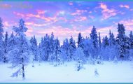
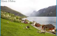
Norwegian Lapland includes the counties of Troms and Finnmark, the coasts of which are much indented by fjords and inlets. In Troms there is still arable land and rich pastureland, but the country to the NE becomes increasingly bare and inhospitable. From the high ranges of mountains in the W, the land falls to low plateaux in the E, with occasional bare rounded hills. The chief towns of the two countries are Tromso ( 268) and Vadso (159).
On the Altafjord in western Finnmark is the important commercial town of Alta (Alta Hotell, 120 Altafjord Vertshus, 97 b.), formerly known as Bossekop in Alta (Whale Bay, from the Lapp word bosso, whale). Alta is the administrative capital of Finnmark and home of the famous Alta Bataljon which covered the retreat of the British and French forces from Narvik and district in 1940, suffering tremendous casualties in the process. The population lives by salmon-fishing and working the local slate. The area around the fjord, which can be surprisingly warm in summer, has a remarkably rich growth of vegetation.
On Road 93 driving S from Alta lies Masi, a very typical Lapp settlement and school where one can see reindeer skins pegged on the walls to dry out and 130 km (SO miles) S of Alta (Road 93), in the Finnmarksvidda, is Kautokeino (pop. 1600, mainly Lapps; Kautokeino Turist-hotell, 92 Kautokeino Fjellstue, 32 youth hostel; camp site), with a new church (1958; the old church, dating from 1703, was destroyed in 1944) and a school.
NE of Alta, on Road 6, is Kistrand, with a pretty little wooden church, on the Porsangerfjord, which extends S for 120 km (75 miles) from HonningsvSg on the island of Mageroy ( 200). The road runs around the end of the fjord and continues to Kirkenes (159). wild mountainous area, largely untouched by man, which reaches its highest point in Kebnekaise (2117 m (6946 ft): 161). A number of rivers, heavily stocked with fish, rise here (Umealv, Skelleftealv, Pitealv, Lulealv, Kalixalv, Tornealv, etc.) and flow SE toward the Gulf of Bothnia. Most of the area is covered with bog and forest; toward the E and N the forest gradually opens and finally ends in a scrub of stunted birch-trees. The inhabitants live primarily by timber-working, with some agriculture and stock-farming. In addition, there are the iron mines of Gallivare and Kiruna. The area is traversed by a number of roads and by the mineral railway from LuleS to Narvik. A great part of it is, however, very difficult terrain and virtually unmapped.
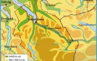
Jokkmokk (Gastis Hotel, 50 Engel-mark, 26 b.), an old Lapp village, is now the chief place in the commune of the same name (pop. 3200). Roughly half the area lies above the tree-line. The village was established by Charles IX as a meeting-place for the Lapps. A Lapp assembly, church festival and fair was held here every February. Some traditions, including the fair, have been preserved. The church (1753) was burned down in 1972 and rebuilt in 1974-5. The Museum contains an interesting collection of material on the culture of the Lapps and Swedish settlers. There are displays of Lapp handicrafts on sale. There is a Lapp secondary school, established in 1942, as well as a school for nomad children.
SURROUNDINGS of Jokkmokk. There are a motor road and a footpath up the Storknabben, the hill of the midnight sun. 1 km (f mile) N are the Kaitum Falls. The Arctic Circle (Swedish Polcirkeln) runs 7 km (4 miles) S of the town. 12 km (7 miles) S is Kaivovallen, an old summer settlement for the Lapps and their reindeer. The hills around Jokkmokk are suitable for both beginners and experienced climbers.
NORWEGIAN LAPLAND Photo Gallery

