Province: Lapin laani (Lapplands IanLapland). Sodankyia Tourist Information Office,
Kantakievarintalo,
SF-99600 Sodankyia; tel. (93) 1 17 44.
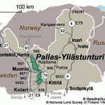
The Pallastunturi Hills, with their treeless slopes, one of Finland’s most popular skiing areas, lie in the lIW of the country, near the Swedish frontier, in the middle of a mountain chain extending from Yllastunturi (740 m 2428 ft) in the S, to Ounastunturi (738 m 2421 ft) in the N. The highest point is Taivaskero (821 m 2694 ft); to the NW is Laukukero (777 m 2549 ft), to the E Palkaskero.
From Muonio (Akaskero Hotel, 114 Olostunturi, 115 b.), a trim village at the junction of the Jerisjoki with the Muortionjoki, the Rovaniemi road (No. 79) runs to the E. 7 km (44-miles): on the right, Olostunturi (524 m 171 9 ft), a hill commanding extensive views (footpath to top). 5 km (3 miles): Sarkijarvi, where we turn left and climb up through beautiful hill scenery. 1 5 km (9 miles): crossroads. The narrow road on the right goes to Pallasjarvi (4 km 24 miles): the left-hand road ascends (7 km 44 miles) to the magnificently situated Pallastunturi-Turisthotel (78 natural history museum), at the foot of Taivaskero (good skiing country; lift). The midnight sun shines here from 27 May to 1 6 July. From here a marked trail runs 60 km (40 miles) NW (5 huts providing overnight accommodation) to Enontekio or Hetta (Hetta Hotel, 20 b.), with a modern church and a silversmith’s workshop. The trail runs through the Pallastunturi-Ounastunturi National Park (area 500 sq. km 200 sq. miles), typical of the barren upland country of Lapland.

