What’s Best: Marin’s longest and least traveled shoreline multi-use path, along San Rafael Bay, perfect for an after-work or morning jog.
Parking: From Hwy. 101 north of San Rafael, take the Francisco Blvd.-Richmond Bridge exit, and veer right off overpass. Continue to traffic light at Bellam Blvd. and turn left. From Hwy. 101 south of San Rafael, take Francisco Blvd. exit and turn left on Bellam. For both directions: From Bellam Blvd, continue across Francisco and turn left at traffic signal on Kerner Blvd. Follow Kerner to end at Canal St. and turn right. Park near Pickleweed Park. Note: Shoreline is the former name of this park. Agency: San Rafael Community Services Department
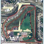
STARKWEATHER PARK MAP SAN FRANCISCO Photo Gallery
Hike: Lagoon point (1 ml.); San Rafael Bay shoreline (3.75 ml.)
Hidden east of an industrial park and the Highway 101 corridor, Starkweather Park’s scenery may come as a surprise. For both Starkweather Park walks, start east, away from Pickleweed Park along the bay. A mile offshore in the bay are the two Marin Islands, a National Wildlife Refuge. An exercise station and benches mark lagoon point, at the end of a straight section. You have a view of the Richmond-San Rafael Bridge, whose double steel suspensions echo those of the Bay Bridge in the distance.
To walk the entire San Rafael Bay shoreline, continue on the path along the south side of the lagoon for a short distance, and then turn left, or south, on the long, stretch of path that follows the shoreline. The multi-use path ends on the north side of Pt. San Quentin; one .25-mile section may not be paved. More Stuff: The south side of Shoreline Park path may be accessed from Pelican Way. Using the above parking directions, turn right on Francisco from Bellam. Go left on Pelican and park in signed area.
Bike: Starkweather Park’s multi-use path is a scenic secret route for cyclists to get from Larkspur or Corte Madera to San Rafael or Peacock Gap and continuing along the shore to China Camp State Park. To Larkspur Landing, TH29, take the multi-use path, hugging the shore. Turn right before the path ends, on a paved path that leads in from Pelican Way. Go out Pelican, turn left on Francisco, and ride until you see an opening in the chain link fence. Take that opening, heading up a wide bike lane on the Sir Francis Drake exit off Highway 580. Continue over a rise. At the bottom of the hill beyond the prison, cross Sir Francis Drake to a bike path at Remillard Park, and continue to the ferry terminal; see TH29.
To downtown San Rafael or Peacock Gap, head away from Pickleweed Park on Canal Street all the way to Harbor Street. Go left, out to Francisco Boulevard, where you turn right. Hook around to your right, now on Grand Avenue, crossing over San Rafael Creek. To continue on to Peacock Gap and China Camp, turn right on Third Street, which becomes Pt. San Pedro Road. Continue all the way around the point past China Camp State Park to the Marin County Civic Center. Note: To go directly to the Civic Center, stay on Grand Ave, after riding Francisco Boulevard from Canal Street. Grand Street comes to a freeway on-ramp, which cyclists may safely and legally ride to the next exit, which is San Pedro Road.

