
Capital of Guizhou Province
Altitude: 1070m/3512ft, Area: 54sq.km/21sq. miles Population: 800,000 (conurbation 1,310,000)
Guiyang, also known as Zhu, lies at 106° 37’E and 26“34’N, in the centre of Guizhou province and in the middle of a plateau flanked by high mountains. It stretches along the banks ofthe Nanminghe river, a tributary ofthe Wujiang. There are rail links with Chongqing and Kunming and air links with Beijing, Shanghai, Canton and other large Chinese cities.
Guiyang’s origins lie in the dim and distant past. There is evidence that there was a town here at the time of the Han dynasty (206 b.c. to a.d. 220). It served as a military base in the Yuan era (1271-1368). Under the Mings (1368-1644) Xingui, as it was then called, enjoyed a considerable boom; the town walls which still stand date from that period. It has been called Guiyang since 1913. In recent years heavy industry has become established here, as well as chemicals, textiles and consumer-goods.
This triple-roofed building in the town centre stands 20m/66ft high and was built in 1689. The forecourt is adorned with two iron columns, one dating from 1732 and the other from 1797. There are pillars on the inside walls and tablets hanging from the ceiling contain many old inscriptions.
Qianlingshan Gongyuan Park lies 1-5km/1 mile north-west of the town and covers an area of some 300ha/750 acres. It is in fact a miniature nature park, with trees, medicinal herbs, 2500 different species of plants, dozens of rhesus monkeys and 50 species of birds. The park also boasts a picturesque lake encircled by hills.
In the centre ofthe park towers Mount Qianlingshan (1300m/4267ft). From its western peak there is a superb view of the town.
The Temple of Great Fortune was built on Mount Qianlingshan in 1672. It contains several halls.
Behind the mountain an obelisk pierces the skyline above a pine forest. It is dedicated to the victims of the Civil War of 1949.
Nearby will be found Guiyang Zoo, with over80 rare species ofanimalsuch as snub-nosed monkeys, tigers and pandas.
In another corner of the park lies the Cave of the Unicorn, which was discovered in 1531. For many years Generals Chang Hsueliang and Yang Hucheng were imprisoned here by the Guomindang (Kuomintang) nationalist government after having been found guilty in 1937 of collaborating with the Communist Party when Chiang Kai-shek was captured in Xi’an.
Huaxi Gongyuan Park, 17km/1072 miles south ofthetown, lines the banks of the River of Flowers (Huaxi), which forms the Huaxi Waterfall near Bashang Bridge.
This area is called “Flower of the Guizhou Plain” by the local people because of the beautiful scenery. Features of the park include islands, bridges, pavilions and tea-houses.
The Underground Gardens in an extensive cave some 23km/14 miles south of Guiyang were first discovered in 1965. The path through the 587m/1930ft deep cave leads past a number of stalactites and stalagmites, the surreal effect of which is intensified by an effective system of lights.
The Huangguoshu Waterfall is over 60m/200ft high and 80m/260ft wide, making it the largest waterfall in China. It lies 150km/93 miles south-west of Guiyang, where for more than 2km/1 ‘A miles the Baishui river winds its way over nine steep tiers of rocks and the same number of waterfalls.
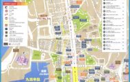
Guiyang Map Photo Gallery

