
Autonomous City
Altitude: 4m/13ft. Area: 6200sq.km/2393sq. miles Population: 8,300,000 (conurbation 14,000,000)
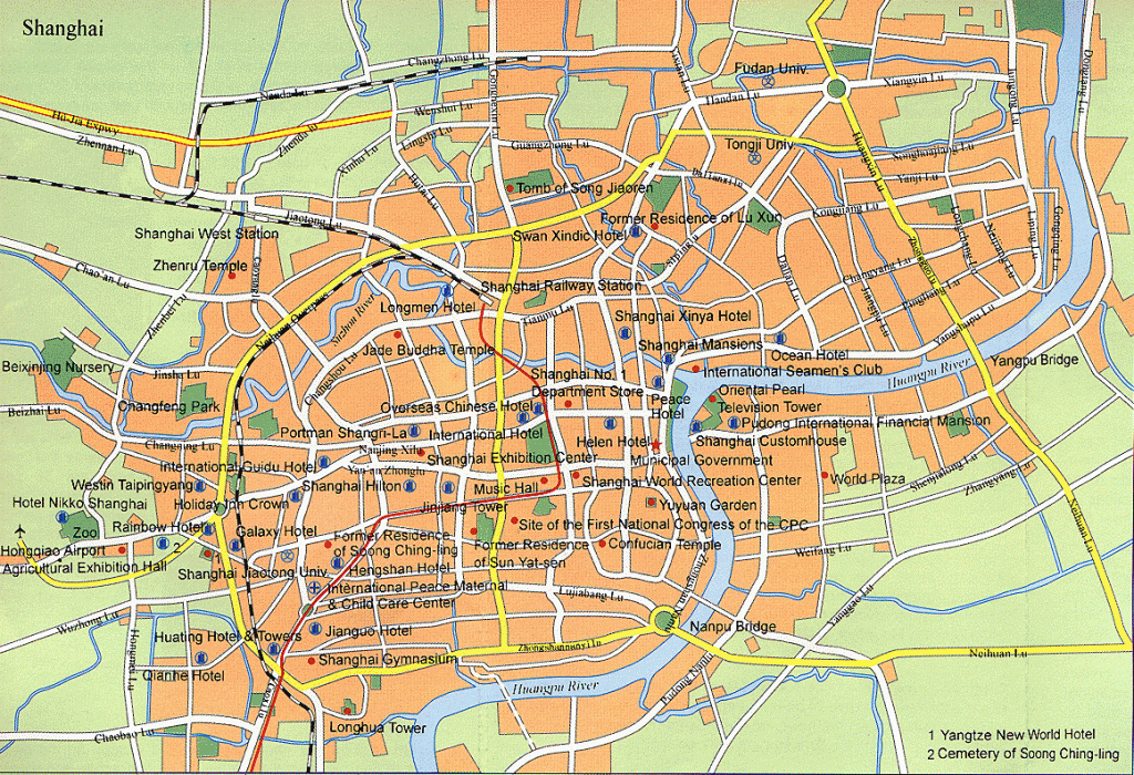
Shanghai lies at 121°29’E and 31°18’N in eastern China, on the Huang-pujiang estuary in the East China Sea.
Shanghai is 1460km/906 miles away from Beijing from where it can be reached in a two hour flight or a seventeen hour train journey. There are also connections by rail and air with Nanking, Hangzhou, Canton and other main cities. There are three shipping lines operating services to Dalian, Tsingtau and Ningbo.
The name Shanghai means “over the sea”. It is the largest city in China and the centre ofthe nation’s trade and industry, with the biggest and most important port in the land. The city is experiencing a meteoric economic expansion, one result of which has been a massive building boom. Much of this activity is focused on the new industrial zone of Pudong, a district in the east of the city reached via the longest suspension bridge in the world.
Almost 200 universities, technical colleges and research institutions also make the city a centre for the sciences.
Owing to the high population density Shanghai has great housing and traffic problems; these should be alleviated somewhat by the opening in 1995 of the city’s underground railway and by the construction in the suburbs of modern dwellings replacing the traditional houses known as lilongs.
The first settlement here was in the Song period (960-1279); itthen became a fishing village, and in the middle ofthe 13th c. a small city grew up on the west bank ofthe Huangpujiang called Shanghai. Its size and importance increased considerably because of a flourishing foreign trade and it almost reached its present size. In the 16th c. silk and cotton weaving developed. During this period a city wall was erected.
From 1843 onwards, after China’s defeat in the opium wars, Shanghai became the free port of various western powers, which forced the Chinese government to concede several districts. It became a European style metropolis, separated into Chinese, French and international sectors. The Chinese viewed the foreigners as a restrictive force, and resistance to them increased.This finally found expression in protest demonstrations by students and workers.
In July 1921 the Communist Party of China was proclaimed here. Chiang Kai-shek brutally brought down the people’s uprising of 1927. After the outbreak of war between the USA and Japan in 1941 the latter occupied the foreign concession. In 1949 following the occupation by the Red Army, foreign concessions and private ownership were abolished. However, Shanghai was still able to continue to assert its industrial pre-eminence. During the Cultural Revolution (1966-76) the city was the base for the “gang of four” led by Jiang Qing. Subsequently, despite the beginnings of liberal economic reforms, Shanghai lost its leading role.
The Zongshan Lu, a river promenade running along the west bank ofthe Huangpujiang, is also known under the Anglo-Indian name of “Bund” (Waitan). The left side ofthe road is lined with numerous buildings put up by the English and French at the time of the occupation; today many of these have been taken over by banks.
Moving from south to north we see the city hall, the bell tower (the former port customs office), the Peace Hotel, the Bank of China, and the Friendship Stores. The right side is taken up by the promenade, lawns and flower beds.
The Oriental Pearl TV Tower (open: 8am-8.30pm), on the opposite side ofthe river in Pudong Park, offers a quite outstanding view.
From Shiliupu Quay, just off Zongshan Lu, it is possible to take a sightseeing tour by passenger steamer around the port and the confluence of the Huangpujiang and Changjiang rivers.
The Nanjing Lu, the principal shopping street of Shanghai was constructed in the second half of the 19th c.; it runs from the Zongshan Lu for several miles towards the west. Here can be found shops of every description, restaurants and cinemas, also the department stores Yibai and Jiubai.
This open green area came into being in the colonial period on the grounds of the racecourse. The former “start” and “finish” buildings today house the city library. The northern part of the site forms the People’s Park, the southern part the People’s Square, which is used for parades.
Displayed in a small museum here are, among other exhibits, bronzes and ceramics.
This museum occupies a new building in the People’s Park (open: Mon-Sat. 8.30am-5pm). Because of its large collection of art, displayed on three floors, it is one of China’s most important museums.
The bronzes date from the Shang and Western Zhou period (16th c-770 b.c.) and the porcelain from the Song, Yuan and Ming eras (960-1644). The oldest ceramics date back to neolithic times (about 7000-2000 b.c.). Also to be seen is a picture and calligraphy collection.
Particularly worth mentioning are the terracotta figures from the tomb sites of Qin Shi Huangdi from Xi’an.
To the south-east of the city centre, bordered by the Renmin Lu and Zongshan Lu streets, extends an area riddled with a maze of little lanes, which was formerly surrounded by a city wall. The hustle and bustle of life and dealing dominates the area. Wandering through the Old Town offers opportunities for shopping or eating and drinking.
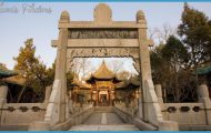
The Yuyuan Garden (open: 8.30am-4.30pm) situated to the north east of the Yuyuan, covers an area of over 20,000sq.m/21,880sq.yd and consists of an outer and an inner garden. The garden was laid out in 1559 by a high state official in the style of Suzhou.
Outside the garden can be found the very popular Tea-House in the Heart ofthe Lake, reached from the bank by a zig-zag bridge.
The Outer Garden, dating from 1559, which was extended in 1577 and renovated in 1760 has a few buildings. The best known of these is the Hall of
Shanghai Map Photo Gallery


