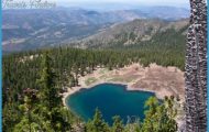
BITTERROOT NATIONAL FOREST
Located in the west-central part of the state, with a portion in neighboring Idaho, this National Forest encompasses parts of two major mountain ranges,
the Bitterroot and Sapphire Mountains, and includes a section of the Continental Divide.
Highest mountain here is 10,157-foot Trapper Peak. There are also canyons and cliffs, rock outcrops, and boulder fields, and amid the snowcapped mountains are scores of lakes and streams, alpine meadows, and spruce and fir forests. Wildlife includes elk, deer, moose, black bear, bighorn sheep, and mountain lion.
An unusually large portion (almost half) of this National Forest consists of designated wilderness areas:194,000 acres of the 2,364,000-acre Frank Church-River of No Return Wilderness, 41,000 acres of the 158,000-acre Anaconda-Pintler Wilderness, and a portion of the 1,341,000-acre Sel-way-Bitterroot Wilderness.
Activities: Hiking, backpacking, and horseback riding are possible on over 1,600 miles of trails, including about 50 miles of the Continental Divide Trail (see entry page 197). High trails are often under snow until mid-July.
White-water rafting, kayaking, and canoeing are available on the Selway and Salmon Rivers. Permits and reservations are required in order to float either river from late spring through summer.
Mountain biking is allowed on many trails, but not in wilderness areas. Cross-country skiing and snowshoeing are trail options in winter. Rock climbing and mountaineering opportunities exist here as well. Hunting and fishing are permitted in season.
Camping Regulations: Camping and campfires are allowed throughout the forest with few restrictions, except where otherwise prohibited. No permits are necessary. It’s suggested that sites be at least 200 feet from water and away from trails.
For Further Information: Bitterroot National Forest, 316 North Third Street, Hamilton, MT 59840;(406)363-3131.

