
Escondido Canyon Natural Area
27200 Winding Way Malibu
Hiking Distance: 3.4 Miles Round Trip Hiking Time: 2 Hours Configuration: Out-And-Back Elevation Gain: 300 Feet Difficulty: Easy
Exposure: Exposed Road And Shaded Canyon Dogs: Allowed
Maps: U.S.G.S. Point Dume Tom Harrison Maps: Malibu Creek State Park Trail Map
Escondido Falls Is A Multi-Tiered 150-Foot Waterfall, The Highest Falls In The Santa Monica Mountains. The Cataract Sits Deep In A Box Canyon Within The Escondido Canyon Natural Area. The Upper (Larger) Cascade Can Be Spotted During The Hike, But The Trail Ends At The Base Of The Lower Falls, Which Tumbles 60 Feet Off Limestone Cliffs Into A Shallow Pool In A Mossy Fern Grotto. To Reach The Upper Falls Requires Actual Climbing, Using Hands And Feet.
Where is Escondido ? Escondido Map Location Photo Gallery
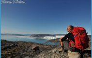
The Trail, A Multi-Use Hiking And Equestrian Trail, Winds Up The Lush Canyon Floor, Criss-Crossing The Year-Round Creek. The Sylvan Path Weaves Through Grassy Flats In The Shade Of Riparian Woodlands To The Waterfall And A Pool. The Hike Begins On A Winding, Paved Residential Road.
To The Trailhead
From Santa Monica, Drive 16.5 Miles Northbound On The Pacific Coast Highway/Highway 1 To Winding Way East And Turn Right. The Signed Trailhead Parking Lot Is On The Left Side Of The Road. (Winding Way East Is Located 4.5 Miles West Of Malibu Canyon Road And 1.3 Miles East Of Kanan Dume Road.)
The Hike
From The Trailhead Parking Lot, Walk North Up Winding Way East, A Paved Public-Access Road Along The Ocean-Facing Slope. Pass Beautiful Malibu Homes Along The Residential Street To The End Of The Paved Road At 0.8 Miles.
On The Left Is The Posted Escondido Canyon Trail, A Dirt Path. Bear Left On The Well-Defined Trail, Crossing The Meadow To The Left. Drop Down Into
Escondido Canyon And Cross The Creek. After Crossing, Take The Left Fork Upstream. (The Right Fork Leads A Half Mile Towards Latigo Canyon.) Continue Up The Near-Level Canyon, Following The Creek Through The Forest. Cross The Creek A Few More Times Under Magnificent Coast Live Oaks And Sycamores. At A Half Mile, The Upper Falls Can Be Spotted At The Back Of The Towering Canyon Wall. After The Fifth Creek Crossing, Lower Escondido Falls Comes Into View. Follow The East Bank Of The Stream To The Trail’S End, Located By A Shal Low Pool Surrounded By Broken Travertine Rock, Ferns, And Moss At The Base Of The Waterfall. Return By Retracing Your Steps.


