
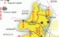
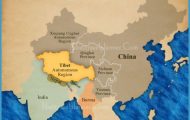
The autonomous region of Inner Mongolia lies between 97°12′-126°04’E and 37°24′-53°23’N in the north of China along the borders with Russia and Mongolia. The vast majority of the population is Han-Chinese, only about 13% being Mongols.
This region consists largely of steppeland and desert and takes in part of the Mongolian plateau, which has an average height of 1000m/3280ft, the desert area ofthe Ordos Plateau, around which the Huanghe flows, and in the north-east the Great Chingan.
The extreme continental climate brings long, bitterly cold winters (the average temperature in January is -10°C/14°F) and only three to five months in summer are free of frost. Rainfall is scarce, with only 150 500mm/6-20in. falling each year. The warmest and at the same time wettest months are July, with an average temperature of 21°C/70°F, and August. 60% of the annual rainfall occurs in these two months.
As early as the 10th c. b.c. the area of Xiongnu was settled. From the 5th c. the Chinese started to build the Great Wall as a defence against the tribes from the steppes. Emperor Wudi of the Han dynasty (206 b.c.-a.d. 220) occupied parts of Inner Mongolia as a way of protecting trade routes with the west.
In the 5th c. Turkish peoples brought the land under their rule. Under Genghis Khan the Mongols defeated the Jin kingdom in the 13th c. and founded the Yuan dynasty. But as early as 1368 the last emperor of this dynasty had to flee back to Mongolia from Beijing.
At the beginning ofthe Manchurian Qing dynasty (1644-1911) the region was annexed to the empire. During this period there was an increase in Han Chinese coming here to settle and this led to uprisings and a struggle for independence.
In 1911 the Mongol freedom fighters succeeded, with Russian support, to achieve independence for Outer Mongolia.
Grazing camels
The invasion of Manchuria by the Japanese in 1931 brought Inner Mongolia into that country’s sphere of influence. Underground groups fought for the region’s independence with help from the Chinese communists.
The autonomous region of Inner Mongolia was established on May 1st 1947, thus before all the other regions which eventually gained autonomy status (Xinjiang, Ningxia, Guangxi and Tibet). In 1949, when Mongolia again came under Chinese rule, as well as on several other occasions during the last 50 years, the region was enlarged. In 1979, after the Cultural Revolution (1966-76), which had led to the territory being reduced in size by almost a third as a result of the Chinese dictators’ fears of separatist aspirations, the boundaries were restored to what they had been in 1956.
Coal, chromium, copper, precious metals and iron ore are all mined (iron Economy and steel works in Baotou). In the salt lakes of the desert areas both salt and soda are also extracted.
About half the province’s area can be used as grazing land (mainly sheep and goats, but also cattle, horses and camels). The government is trying to use financial inducements to persuade the nomads to take up a settled existence.
The only fertile and successfully cultivated area of Inner Mongolia is the valley of the Huanghe, which in its upper course flows for hundreds of kilometres through the province. In these areas given over to agriculture, which is only possible on the 110 to 160 frost-free days in the year, cereals, sugar-beet, oil-seed, potatoes, maize and kauliang are produced.
The towns of Hohhot and Baotou (see entries) can be visited by tourists. Places to visit Anyone seeking a more unusual experience can try sleeping in a yurt (nomad’s skin-covered tent).
Mongolia Map Photo Gallery