
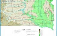
The Paraguay River flows north to south extending 1,260 kilometers down the length of Paraguay, bisecting the country into Eastern Paraguay and the Chaco. The river’s navigability and strategic location between Brazil and Argentina make it a large thoroughfare for commercial transportation, both national and international. Due to poor road infrastructure, the river also serves as the main source of transportation for communities in the departments of Concepcion and Alto Paraguay At its northernmost point (in Paraguay) is the culturally and biologically diverse department of Alto Paraguay. As part of the Pantanal ecosystem, this is one of the best places in Paraguay for nature observation (see Departamento Alto Paraguay – The Pantanal). The area is also home to several indigenous tribes living in small communities along the riverbanks. Near the border with Bolivia and Brazil is the small town of Bahia Negra. Although remote, it is still serviced by boat, bus, and airplane, making it an ideal place from which to venture into the practically uninhabited wilderness of the Pantanal. The Los Tres Gigantes birding station to the north along the banks of the Negro River is an ideal spot for nature observation. Neighboring Bahia Negra is the Ishir community of Puerto Diana where the indigenous still maintain their ancestral traditions.
Flowing 160 kilometers south in a series of large looping twists and turns, the Paraguay River passes Fuerte Olimpo. Located at the base of The Cerro Tres Hermanos mountains, it is considered the gateway to the Paraguayan Pantanal. As capital of the Department of Alto Paraguay, Fuerte Olimpo has more infrastructure and services than ports further upriver. Another 150 kilometers to the south is Colonia Carmelo Peralta where travelers can pass through Paraguayan Immigration before entering the Brazilian tourist town of Porto Murtinho on the other side of the river.
Further downriver are the port towns of Puerto Casado and Puerto Pinasco. During the tannin boom in late 1800’s and early 1900’s these towns were home to foreign owned tannin processing plants (see Carlos Casado and the Tannin Industry). When this industry collapsed, many found jobs in the quarries of Vallemi on the opposite bank of the river. Located on the northwestern-most tip of Eastern Paraguay, Vallemi is the site of Paraguay’s National Cement Factory and home to many small scale quarries. There are also a handful of limestone caverns that can be visited with guides (see Caves of Vallemi and San Lazaro). Just past Vallemi is the Apa River, a fast-changing river that marks Paraguay’s northern boundary with Brazil. This also marks the southernmost limits of the Paraguayan Pantanal.
About 140 kilometers to the south of Vallemi is the city of Concepcion, one of the largest ports along the Paraguay River. Goods, from the Chaco to the west and Pedro Juan Caballero and Brazilian state of Matto Grosso to the east, have traditionally been transported here before being shipped downriver to Asuncion and Buenos Aires. As the port of call for passenger ships making their way north to Bahia Negra and south to Asuncion, Concepcion is an increasingly popular stop among adventurous backpackers. Approximately 110 kilometers south is the small port of Puerto Antequera. This port is used mostly to transport agricultural products from the Department of San Pedro, whose capital, the city of San Pedro del Ycuamandiyu, is fourteen kilometers to the east. Villa Hayes is the last major port before the city of Asuncion. Originally the failed Nueva Burdeos (New Bordeaux) colony, this is the site of one of Eliza Lynch’s most infamous tantrums (see The Infamous Eliza Lynch).
Asuncion, capital of Paraguay, is located 872 kilometers to the south of the border with Bolivia and Brazil. The city’s port is located in the bay of Asuncion, which is also internationally recognized as an Important Birding Area. There are no passenger ships that travel south of Asuncion to Pilar, although it is possible to hitch a ride on a cargo ship to the city of Pilar. Before meeting up with the Parana River and flowing across the international border with Argentina, the Paraguay River passes the historic site of Humaita where picturesque ruins from the Triple Alliance War remain on the riverbanks to this day.
The Paraguay River Photo Gallery


