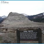
Due east of Soda Butte is Mount Norris. Philetus W. Norris was the eccentric but effective second superintendent of the park (1877-82). He was also a prolific writer; his writings include poetry about the west, a road guide to the park, and excellent superintendent’s reports that are invaluable to historians. Besides Mount Norris, several other park features carry his name, including Norris Geyser Basin and Norris Pass. In 1886, when the U.S. Cavalry patrolled the park, a soldier station was built just across the road from Soda Butte. Later used as a ranger station, the wooden structure was moved to the Lamar Buffalo Ranch in the 1930s. In army days, the park had 19 soldier stations, sometimes called snowshoe cabins. They were lonely outposts built to shelter soldiers on patrol in the wintertime. Scattered about the park today are about 40 patrol cabins that shelter rangers, but the rangers don’t usually stay in them for weeks at a time as the soldiers Superintendent Norris often did. 14.0/14.6 @ Lamar River Trailhead, and a large parking area for Specimen Ridge, Lamar Valley, Cache Creek, and Miller Creek trails.
This is the starting point for long trails up Specimen Ridge or into the remote backcountry. One can hike or ride horseback up the Lamar River and east of the Mirror Plateau into mountainous areas to Yellowstone’s eastern boundary and beyond. All trails cross a sturdy footbridge over Soda Butte Creek. The apparatus near the bridge measures the flow of water. Historic remnants hike. History buffs might enjoy a short walk from this trailhead to some historic points from the 19th century. Cross the Soda Butte Creek footbridge to look for remnants of the Gardiner to Cooke City miners’ road. According to the late Yellowstone historian Aubrey Haines, the two deep tracks that can still be seen paralleling Soda Butte Creek were left by miners. The men dragged an arrastre (a heavy apparatus for grinding ores, pronounced a-RASS-treh) along the valley. Farther along the trail, you might look for the scant remains of a cabin built for gamekeeper Harry Yount. About 1.6 miles (2.6 km) from the parking area, you can still find chimney stones and traces of a spring box at the base of the hill near the trail junction. Over 100 years later, tall, deep green rye grass still gives away the area where Yount pastured his horses.
If you reach the point where you would have to ford the Lamar River, you’ve gone beyond the remnants. 14.4/14.2 @ S© Alternate access to the Lamar Valley trails. This one is used especially by horseback riders, who take guided pack trips into the mountains. 14.9/13.7 Located just up the hill from the present road was an especially steep section of the old road, the Jackson Grade. George Jackson squatted (that is, settled without legal claim) near here in the 1880s. 15.3/13.3 Confluence of Soda Butte Creek with the Lamar River. The Lamar River valley is a summer feeding ground for bison, so your chances of seeing them along this stretch of road are excellent. Near here was the site of an elk corral, used to trap elk and reduce the size of the herd for about 30 years in the mid 20th century.

