Category: Destinatios
Mucker Lake-Border Route MILES DESCRIPTION 0.0 Walk ahead on Forest Road 317. 0.1 Boundary Waters Canoe Area Wilderness (BWCAW) permit box at a fork in the trail. Fill out …
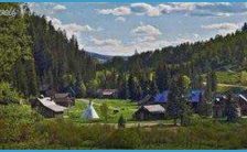
Mucker Lake-Border Route Trail Highlights The Mucker Lake-Border Route circuit heads east from the trailhead at Mayhew Lake to Float Lake. This trail stretches along a valley floor following …
Mucker Lake-Border Route Drive north on the Gunflint Trail (County Road 12) for about 34 miles to Forest Route 317 and turn right. Go one-half mile to a small …
Mucker Lake-Border Route SUPERIOR NATIONAL FOREST GUNFLINT RANGER DISTRICT DIFFICULT-STRENUOUS LENGTH 5.4 miles TIME 3:45 DIFFICULTY ROUTE-FINDING MAPS & PERMITS GETTING THERE TRAILHEAD GPS Difficult-Strenuous. While only 5.4 miles …
GRAND MARAIS OVERLOOK MILES DESCRIPTION 0.0 The hike heads north from the parking lot passing a signboard with information about the Superior Hiking Trail (SHT). Almost immediately pass trails …
GRAND MARAIS OVERLOOK In Pioneers in the Wilderness, a history of the settling of Grand Marais and Cook County, author Willis H. Raff relates another story about the name …
GRAND MARAIS OVERLOOK The route of this hike incorporates the large Pincushion Mountain Loop with a short side trip to the summit of the peak. From the trailhead, which …
GRAND MARAIS OVERLOOK MODERATE LENGTH 4.4 miles TIME 2:30 DIFFICULTY Moderate ROUTE-FINDING MAPS & PERMITS GETTING THERE TRAILHEAD GPS Easy A map of the Pincushion Mountain trails is available …