
What’s Best: A full day trip: Picnic or stroll along several miles of bay coastline trails and bluffs, visit a historic fishing village, or venture inland on woodland trails spread out over 1,500 acres.
Parking: From south of San Rafael on Hwy. 101, take the central San Rafael exit and then turn right Second St, which blends with Third St. Continue east as Third becomes Pt. San Pedro Rd. East boundary of the park is about 5 miles from Highway 101. From north of San Rafael on Hwy. 101, take the Marin Civic Center-N. San Pedro Rd. exit. Drive east on N. San Pedro for about 3 miles, to west boundary of China Camp. Notes: China Camp State Park covers about 3 miles of shoreline with numerous access points. Hiking descriptions below are referenced from the east boundary. Parking fees may be required at some areas. Agency: China Camp State Park. Note: Budget cutbacks may limit hours at campgrounds and restrooms, and close parking lots. Trails remain open.
San Pedro Ridge and China Camp
China Camp Village-Rat Cove (up to .75 ml.); Bullhead Flat loop Hike: (3.75 ml.); Chicken Coop Hill (.25 ml.); Turtle Back loop (1 ml.); Back Ranch Meadows loop (4.5 ml.).
In the early 1800s, this area and surrounding hills became part of a large Mexican ranchero. In the late 1850s, when ranchero grantee Timoteo Murphy died, the area was subdivided, and in 1868 the present-day park was purchased by George McNear whose descendents today run the brickyard on San Pedro Point. In the 1870s, some 10,000 Chinese grass shrimp fishermen lived along the coves and beaches of San Pablo Bay. A few buildings, a dock, and foundations remain as does shrimp fisherman Frank Quan, the village’s only resident and descendent of the early shrimpers. The state purchased the China Camp acreage in 1977.
To the park’s highlight is a stroll of China Camp Village and the short walk to adjacent Rat Rock Cove. Parking: Turn about .5-mile from the park’s east boundary. The trail to the cove is one-tenth of a mile west of the top of the road down to the village. You’ll see tiny Rat Rock, one of the shrimping spots, a short distance offshore. The village site is down the road. The camp’s plank pier and vintage buildings will give you a sense of history. To make the history come alive (on weekends), stop at the China Camp Snack Shop, operated by the Quan family, or drop by the building complex on the water to talk to one of the park’s informed docents. A grassy picnic area sits on a knoll above the village.
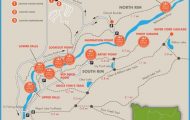
CHINA CAMP MAP SAN FRANCISCO Photo Gallery
The Bullhead Flat loop gives you a look at the coastal as well as woodland flora. Parking is about a mile from the park’s east boundary. Park at the beach parking or on the road, and walk in a short distance to the ranger station. Take the trailhead up to your right along split-rail fencing, and keep right, on the Shoreline Trail. After almost 2 miles on this contour, 100 feet or less above sea level, turn left on the Miwok Trail. After some 400 feet of climbing over the next .5-mile, you’ll come to the Bay View Trail. Turn left, returning to Bullhead Flat, a mile away over a rough contour. Note: Bay View Trail and Oak Ridge Fire Road run close together along this last part of the hike, intersecting in two places. Both routes wind up back where you want to be.
China Camp Village Shoreline Trail
The short walk to the top of Chicken Coop Hill, a knoll with a good bay view, begins about 2 miles from the east boundary across from the road into Miwok Meadow. Start to your left as you face the hill. A trail curves around to the bay side and then to the oak-studded top. The Turtle Back loop is the best wetlands walk in China Camp. Begin 2.5 miles from the east boundary, or just .5-mile in from the west. A nature trail encircles the oak island, with interpretive signs along the way. Off the tip of Turtle Back, is smaller Jakes Island.
For the Back Ranch Meadows loop, the most strenuous hike for this trailhead, begin at the campground entrance that is about .25-mile from the west boundary of the park. Go to the left of the ranger station and you’ll see Back Ranch Fire Road, a reddish scar going straight up the hillside. Start up this road, beginning nearly 600 feet of upping, the last part on switchbacks. Near the top, you join the Bay View Trail China Camp’s high trail contour. Go to your right. After .5-mile you’ll come to a junction leading to Bayhills, which you pass, keeping right. You’ll dip in and out on a contour toward the bay through leafy forest.
About .75-mile past the Bayhills junction and where a power-line road goes to your left you begin a quick descent via switchbacks, coming out near the campground entrance.
Bike: San Pedro Ridge is a popular mountain biking area that can be accessed from all points on the compass; you’ll also want to check out TH34, San Pedro Mountain Preserve, and TH32, Peacock Gap. For a relatively leisurely ride through China Camp State Park, try a Shoreline Trail loop of about 6 miles. Start at either the entrance to Back Ranch Meadows Campground on the west end of the park, or at Bullhead Flat Ranger Station. From either, get on the Shoreline Trail, which dips in and out of woodlands, making a contour about 100 feet above shoreline. You can return via San Pedro Road to your starting point.
For a more ambitious Bay View Trail loop, start at the Back Ranch Campground Road. Take the Shoreline Trail to the right of the gate at the road. In less than .25-mile, take the Bay View Trail to your right. After about .25-mile, the Bay View Trail begins a series of switchbacks, gaining almost 200 feet in short order. At the beginning of the switchbacks, you have an option of taking Powerline Road to your right; this road takes the climb on a big, sweeping turn and joins the Bay View Trail. Either way, after the elevation gain, you continue a fairly steep ascent of some 300 feet over the next .75-mile where you pass a Bay View Trail spur that leads to Bayhills Road and the Nike platforms. The Bay View Trail follows a ragged contour, passing the Back Ranch Fire Trail. About a mile past this junction, turn left, going downhill on a segment of the Ridge Fire Trail that joins the Miwok Fire Trail. Keep left at the Miwok junction and drop down another 300 feet, reaching the Shoreline Trail. Go left on the Shoreline Trail, for your return to Back Ranch.

