
The Skalkaho Highway Porters Corner to Hamilton
Estimated length: 71 miles
Highlights: Skalkaho Pass, Sapphire Mountains, Gem Mountain Sapphire Mine, Rock Creek, Skalkaho Game Preserve, Skalkaho Falls, Daly Mansion
Getting there: Exit I-90 either at Anaconda (Exit 208) or Drummond (Exit 163) to reach the highway from the east side; each approach is on MT 1, the Anaconda-Pintler Scenic Route.
From the west, take US 93 at Missoula and head south through the Bitterroot Valley to Grantsdale, about 3 miles south of Hamilton. For an extra-adventurous approach especially if you’re a fly angler take the Rock Creek turnoff on I-90 (Exit 126) and drive south along the creek, one of Montana’s blue-ribbon trout streams, to the road’s meeting with MT 38 about 12 miles west of Porters Corner.
Don’t be fooled by the state-highway designation. For at least one-third of its length, MT 38 between the Flint Creek and Bitterroot valleys is anything but a highway. It’s a narrow, twisting gravel road through some of southwest Montana’s prettiest scenery.
Skalkaho comes from the Salish words skalen (beaver) and kalalko (green woods), the literal translation being beavers of the green woods and the direct reference being to Skalkaho Creek. For generations, the Salish used this route over the Sapphire Range, and then in 1924, the state and the Forest Service built the current road to facilitate access to the mines. The highlight literally and figuratively is 7,260-foot Skalkaho Pass at the crest of the north-south Sapphire Mountains, so-named for their abundant minerals. This drive is purely about scenery and wildlife viewing; there are no services or any other commercial endeavors except for the Gem Mountain Sapphire Mine about 13 miles into the route along Rock Creek. The road rises gently to the pass from the east side along the East Fork Rock Creek, through a variety of forest lands, then descends more noticeably in the west to the Bitterroot Valley.
SIDE TRACK
Rock Creek Road: Philipsburg to Clinton (65 miles)
Rule No. 1 for this dusty, bumpy, twisting drive: bring your fly rod. As any angler worth his 9-weight knows, Rock Creek is one of the state’s blue ribbon trout-fishing treasures, albeit often crowded on weekends. It helps that the road charts the stream’s course, making it easily accessible, and that more than half of the creek’s journey to the Clark Fork River at Clinton flows through national forest lands. The creek which has the size and power of a river cuts a shaded ribbon between the steep hills of the John Long and Sapphire mountains. From Philipsburg, take paved MT 348 west across a low pass in the John Long Mountains to its meeting with Rock Creek at Bohrnsen Memorial Bridge. Continue straight on gravel, headed downstream. Aside from its famous concentrations of trout, Rock Creek is also known for a smattering of well-preserved old homesteads, most notably Morgan Case and Hogback. Also noteworthy is the Rock Creek Microburst Site, where an interpretive sign explains how a tornado-esque convergence of nature’s forces in 1989 conspired to mow down hundreds of ponderosa pines on the mountainside across the creek. The road also has several campsites, the upscale Morgan-Case Homestead Forest Service rental cabin, and several trailheads that lead into the surrounding mountains, including the Welcome Creek Wilderness Area. Though the road mostly serpentines with the creek, there are a couple steep spots, so don’t take your motorhomes or trailers on this one.
A LITTLE FIXER-UPPER ON THE BACKROAD BETWEEN PHILIPSBURG AND ROCK CREEK
Porters Corner is at the junction of MT 1 and MT 38, about 6 miles south of Philipsburg. As you turn west on MT 38, look for moose in the willows on Flint Creek. In about 9 miles the paved road reaches East Fork Rock Creek, the headwaters of one of western Montana’s premier trout fishing destinations. The upper stretches get less pressure because of the distance from Missoula, so there’s a good chance you’ll have the creek to yourself.
After following East Fork Rock Creek for about 5 miles, the West Fork joins to form the main branch of Rock Creek. The highway follows the West Fork Rock Creek on paved road for about 4 miles before turning into a glorified Forest Service Road that’s closed for all but summer and early fall to automobile traffic (the groomed trails are popular among snowmobilers). A few miles before reaching the summit is the primitive Crystal Creek Campground, with three sites. At the pass, FS 1352 veers to the north toward the Skalkaho Game Preserve, a 23,000-acre forest and meadow area known for its birds, elk, deer, and occasional black bear. Three twisting miles below the pass is the route’s primary attraction: the oft-photographed Skalkaho Falls, which lie in a popular day hiking and picnicking area. The falls tumble 150 feet over rocks just off the road.
Donna Mitchell
SKALKAHO FALLS BETWEEN PHILIPSBURG AND HAMILTON IS A HIGHLIGHT OF THE DRIVE
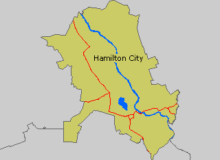
From the falls, the road bends to the southwest and follows Daly Creek to a Darby Ranger District station and Black Bear Campground, another primitive Forest Service site with six camp spots. Hamilton (pop. 3,705), where the notorious Calamity Jane once operated a cafe, was a timber town but is now recasting itself as a tourist destination. Attractions include the Daly Mansion, built by former copper magnate and town founder Marcus Daly, and Rocky Mountain Laboratories, which was created to combat Rocky Mountain spotted fever but has since gone on to study some of the world’s most dangerous diseases.
Hamilton Map Photo Gallery


