
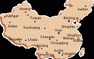
Jilin lies in north-east China, on the border with Russia and North Korea, between 121°38′-131°17’E and 40°52′-46°18’N.
The province is called “Jilinwula” in Manchurian, which means “along the Song-hua River”. Around 30 ethnic minorities, including Koreans, Hui, Manchurians and Mongols, live here.
Jilin takes in parts ofthe fertile Manchurian plains belonging to the catchment area ofthe Soghuajiang, the most important river in the province, and also part ofthe East Manchurian wooded mountain areas.
The continental climate brings long cold winters and short summers. The temperature regularly falls below zero on as many as 240 days each year. Most of the rainfall, which decreases as one goes west, occurs between May and September.
The province, which was founded in 1907, formed part ofthe puppet state of Manchuguo after the Japanese occupation. In 1945 Russian troops marched into Jilin, followed by Chinese nationalists, who were subsequently driven out by the Communists in 1948.
There is a wide-ranging industrial base supported by rich mineral reserves (coal, slate, iron, copper, lead, zinc, silver and gold).
Agricultural products include soya beans, maize, sugar-beet, kauliang, rice, sorghum and millet. Timber (27% ofthe province is forested) and furs are also important.
The province of Jilin is one ofthe birthplaces ofthe Manchurian civilisation and therefore can offer many places of interest, of which the most important are Changchun (see entry) and Jilin, which has given the province its name.
Province: Jilin. Altitude: 150m/492ft. Area: 271sq.km/105sq. miles Population: 837,000 (conurbation 1,070,000) The city of Jilin lies on the Di’er Songhuajiang in the centre ofthe province of Jilin at 126°30’E and 43°48’N.
It is situated about 100km/62 miles from the provincial capital Changchun and can be reached from there in about 2 hours by train or bus.
Jilin is over 300 years old, the city’s beginnings dating back to 1673 when a wooden defensive ring was built. This was replaced by clay ramparts in 1727. Today Jilin is an important provincial centre for trade and industry (foodstuffs, chemical and electrical goods).
Beishan Park, situated in the south-west ofthe city, consists mainly of hills rising to a height of some 200m/650ft. In the eastern part are the Temple of the War God (Guandi Miao; 1692) and the Pavilion of the Jade Emperor (Yuhuang Ge; 1725). These temples and a viewing pavilion provide a fine panorama of the city.
24km/15 miles south-east of Jilin lies the reservoir, Lake Songhua Hu. It is situated next to the hydro-electric power station of Fengman, which receives its water from the Songhuajiang. The picturesque and peaceful lake with its clear water extending over an area of 550sq.km/21 Osq. miles is a popular place with visitors. Five Tiger Island (Wuhu Dao) is a favourite spot for bathing, boating and fishing.
The ruins ofthe Bohai Kingdom, which was founded in 698, are to be found in the south-east of Dunhua, about 150km/93 miles south-east of Jilin. They comprise the remains of the walls surrounding the capital Aodong and about eighty tombs in which members of the royal family are buried.
Jilin Map Photo Gallery

