
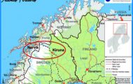
Counties: Viborg amt, Nordjyllands amt.
Store Torv DK-7700 Thisted; tel (07) 9219 00.
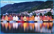
The Limfjord is a strip of water 180 km (110 miles) long, extending from the North Sea to the Kattegat. It separates the Norrejyske 0, the island of North Jutland, from the rest of Jutland. With its beautiful scenery and calm water it offers ideal sailing conditions; its many little ports and anchorages provide every facility for those who enjoy a vacation on the water or merely messing about in boats.
A fishing boat in the Limfjord
A brochure listing all ports and anchorages is available from local tourist information offices. Motorists should bear in mind that the Limfjord can be crossed only at certain places. There are bridges over the Oddesund, Vilsund and Sallingsund (island of Mors) and the Aggersund, and a bridge and tunnel at Alborg. In addition there are a number of ferries which make the crossing in a few minutes, including one at each end of the fjord.
The western entrance to the Limfjord from the North Sea is the Thy boron Channel (ferry), on the N side of which is the popular vacation and bathing area around Agger and Vestervig. Vestervig, in the 11th c. the seat of the bishop of Vend-syssel (the most northerly part of Jutland), is now a small village with less than 1000 inhabitants. The church, a three-aisled basilica, still recalls the great days of the past. After heavy alteration and restoration through the centuries, it was restored to nearly its original form in the 1920s. It contains a number of Romanesque tombstones, including the oldest dated stones in Denmark (1210).
Vestervig suffered a rapid decline after its harbour silted up; many other ports on the Limfjord met the same fate. The process of silting up alternated with storm tides which wrought havoc with the land, and much fertile land as well as a number of towns disappeared underthesea. The tiny church and beacon tower of Lodbjerg, standing solitary among the dunes, bear mute witness to this destruction. The Agger Tange, a spit of land on the N side of the Thyboron Channel, is now protected by dikes and groynes, following the example of Holland.
On the S side of the Nissum Bredning, at the Wend of the Limford, is Lemvig (pop. 6500; Scandinavian Holiday Center, 148 apartments, SP; Missionshoteller, 66 Norre Vinkel Hotel, 72 camp site), an attractive town in a hilly setting (Gothic church, interesting museum). The surrounding area is a paradise for nature-lovers with its expanses of woodland, bog and heath, the sand dunes on the W coast (such as the Bovbjerg Klint, 43 m (1 41 ft) high, 12 km (7J miles) W of Lemvig) and a distinctive fauna which includes many rare species of waterfowl.
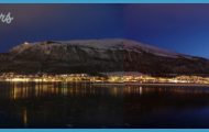
From Lemvig a good road (No. 11) skirts the fjord and crosses a bridge over the Oddesundon tothe Thyholm peninsula. It then continues along the NW side of the Limfjord to Thisted, the chief place on Thyholm (pop. 11,000; Missionshotel Merci, 50 Strandhotel, 40 camp site), which has a library with paintings by Jens Skovgaard and a museum with an interesting historical collection.
22 km (14 miles) N of Thisted lies the little port and fishing village of Hanstholm, at the NW tip of Thyholm. To the S is the resort of Klitmeller, named after the old water-mills which once stood here (very good beach). Beyond Thisted, Road 11 continues E to Ferritselv, Brovst and Abybro, where it turns N. From here Road 17 runs SE along the Limfjord to Alborg (55), through a region of plantations, forest and small fjords; it is less than half an hour’s drive to the North Sea from this road. An interesting feature at the W end of the Jammerbugt is the Skarreklit, an isolated rock 15 m (50 ft) high which once was part of the coast but now stands 1 00 m (110 yds) offshore.
In the Limfjord itself there are several islands of varying size; the largest, Mors, can be reached by bridges over the Sallingsund to the S and the Vilsund to the N or by ferries over the Neessund and the Feggesund. The charm of Mors lies in its magnificent scenery. A particularly notable feature is the Hanklit, a 65 m (200 ft) high crag which falls almost vertically to the sea and contains animal and plant fossils of the Tertiary period. The rock has been carved into fantastic forms by Ice Age glaciers. At the northern tip of Mors is the Feggeklit, on which, according to legend, Hamlet killed his stepfather, Fegge.
The chief town on Mors is Nykobing (pop. 10,000; Bendix Hotel, 56 Sallingslund Faergekro, 82 b.), noted for the culture of oysters and as a herring-fishing port. The Mors Historical Museum is in Dueholm Abbey: only one building of the original abbey, founded by the Knights of St John in 1370, is still preserved.
To the E of Mors on the little island of Fur is a museum containing a large collection of fossils. An overall view of the island’s beautiful natural scenery is possible from the Stendalshoj.
Beyond Alborg, the Limfjord runs E in a narrow channel, the Langerak, into Alborg Bugt on the Kattegat. There is a ferry across the mouth of the Langerak from Hals (Hals Hotel, no rest. 31 b.), a resort with remains of its old fortifications (Powder Tower, Armoury).
Limfjord Denmark Jutland Map Photo Gallery


