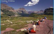
What’s Best: Take a jetty walk onto San Rafael Bay to see Marin Islands; or hike up 1,000 feet on San Pedro Ridge’s secluded trailheads.
Parking: From Highway 101, coming from either north or south of San Rafael, take the central San Rafael exit. Head east on Second St, a oneway street. Second blends with Third St, which in turn becomes Pt. San Pedro Rd. Note: This trailhead has several access points, which are listed below in succession, heading from west to east on Pt. San Pedro Rd. Agency: San Rafael Community Services Department; China Camp State Park; Marin County Department of Parks.
PEACOCK GAP MAP SAN FRANCISCO Photo Gallery


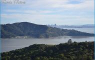
The Peacock Gap trailhead covers the uplands and shore of San Rafael Bay, beginning from the south at San Rafael Creek and extending north to Point San Pedro. The Loch Lomond Jetty takes you onto the harbor to a spot less than a half-mile from Marin Islands. Parking: Continue east on Pt. San Pedro Road and turn right on Loch Lomond Drive. Go all the way to the left in the marina parking lot, where you’ll see the path leading out to the jetty. Marin Islands were a last refuge for Coast Miwok led by a warrior later called Chief Marin who tried to fight off Mexican soldiers in 1824.
The trail to San Pedro Mountain from Main Drive, sees few hikers and delivers a bay vista. Parking: Turn left on Main Drive off Pt. San Pedro Road, which is after Bayview. Take Main up to its end, under eucalyptus trees with a gated fire road going up to your left. This access is through Harry A. Barbier Park, San Rafael’s undeveloped open space adjacent to the south side of China Camp State Park. You climb more than 800 feet, if you make the San Pedro Summit.
Bear right a short distance from the trailhead; the left road is a spur coming in from the end of Bayview Drive. The road ascends fairly steeply, soon coming to open oak-and-grass hillsides with big bay views. Stay on the main road, Bay Hills Fire Road, ignoring side trails and roads. After about .75-mile, and a 400-foot gain, you’ll level out on open hills studded with oaksThe road then enters dry forest and climbs steeply on the last surge to the ridge. On top, you come to a roughly paved ridge road. To San Pedro Mountain, go right on the road, passing the big fenced antenna. After an undulating .25-mile, the road goes over the top of the mountain, which is a large, flat clearing fringed by madrone and oak trees.
The Knight Drive hike accesses the remote upper east side of China Camp State Park. Parking: Turn left on Knight Drive, just past Main Drive off Pt. San Pedro Road. Take Knight to its end at the top and park at a gate. A steep connector trail brings you from the gate to China Camp trail signs. Go left on the main fire road, toward the Back Ranch Fire Road junction, .75-mile distant. To continue to San Pedro Mountain walk past the Back Ranch Road junction, ascending about 200 feet on a half-mile segment. You reach the San Pedro Ridge Road. Turn left, or south, on the paved ridge road, grunting up 100 feet steeply and briefly to the rounded top of San Pedro Mountain.
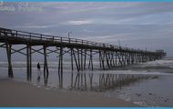
To McNears Beach County Park is 55 acres of landscaped beachfront on the San Pablo Bay. Parking: turn right on Cantera Way. The turnoff is up the hill from Point San Pedro, occupied primarily by historic McNears Brickyard. (Tons of red brick were barged from here to build San Francisco. Nearby, G.F. Steigerwalt’s concrete block company provided much of the material that was used to help re-build Pearl Harbor.) McNears Beach draws crowds to its seasonal swimming pool, sand beach, picnic areas and a fishing pier that juts 500 feet into San Pablo Bay. Note: Admission fee required.
The Biscayne Drive-Shoreline Trail, a woodsy stroll, begins at the east boundary to China Camp State Park. Parking: Pass Cantera Way. At the top of the rise, park on the left at the intersection of Biscayne Drive and Pt. San Pedro Road. Or, just as your make a left on Biscayne, park at a gate. Both parking areas have trails that lead to the same point. You soon cross the state park boundary on the Shoreline Trail. After a pleasant woodland contour, the Shoreline Trail reaches the ranger station at Bullhead Flat. Cross the road and take the trail up on the other side. Continue west, to your right, on the Shoreline Trail past the Peacock Gap Trail junction. After another 1.5-miles walking with tree-filtered views from 100 feet above San Pablo Bay you come to the Miwok Trail. Energetic hikes can head high on the Miwok Trail and loop back. Be Aware: Poison oak thrives here.
Bike: Road cyclists can take San Pedro Road around the point to the Marin Civic Center and circle back to the south side of San Pedro via Grand Avenue. See TH35. For a hefty pump up San Pedro Mountain, use the Main Drive access in the hiking description above. From just north of the top of the mountain, turn right from the ridge trail, coming to Knight Drive. Then descend on asphalt to Pt. San Pedro Road. Return to Main Drive to complete a loop of 6 miles, with some 1,000 feet in elevation gain. From the paved ridge trail at the top of the Main Drive access, you can turn left and, .25-mile later, go right down Gold Hill Grade to the Dominican University Campus. From there, take Grand to Third Street, and go left toward Peacock Gap.