
Province
Area: 195,OOOsq.km/75,270sq. miles Population: 33,630,000. Capital: Xi’an
Shaanxi lies between 105°29′-111°15’E and 31°42′-39035’N in the north of China with the River Huang flowing through the province from west to east. In the east the River Huanghe separates Shaanxi from the province of Shanxi. The southern border runs over the Micangshan and Dabashan mountains (up to 2709m/8888ft).
The plain ofthe Huang, where about half the population lives, is the main residential and industrial area ofthe province.
Shaanxi incorporates a loess plateau (1000-2000m/3281 -6562ft), dominated by the mountainous area of Baiyushan with its deep valleys. To the south is the adjoining Huang plain which lies at 300-600m/984-1968ft, and which is bordered by the Qinlingshan (the highest mountain is the Tai-
The Qinlingshan forms the border separating the steppe climate in the north from the humid subtropical climate in the south. Precipitation, whroh declines towards the north, falls between May and October.
Finds from the mesolithic and neolithic period verify that the valley of the Huang was among the earliest areas in China to be inhabited by humans. The Zhou dynasty resided here (11th c-221 B.C.), as did the Qin dynasty (221-206 e.c).
Until the 9th c. Shaanxi remained the political, industrial and cultural centre of China, when the seat of government was transferred to the east and the north. The area suffered a decline between 1876 and 1879, and in 1928 several million people starved to death here.
In the development of trade and industry Shaanxi stands far behind that of the coastal provinces. Its most important branches of industry are cotton manufacture and engineering, followed by coal and oil production, iron metallurgy, chemicals, building materials and electronics. Coal and iron-ore are mined, and oil, gold and salt extracted. Energy is produced by thermal and hydro-power stations on the Hanshui.
Varying climatic zones determine the type of agriculture here. The growing period in the south is 260-280 days a year, in the Huang valley it is 240 days and in the north only 190 days a year. In the Huang plain, wheat and cotton are cultivated, in the south rice, maize, and pulses are grown, also oranges and tea. The most important agricultural produce in the north is millet and wheat. Roughly a third ofthe arable land is irrigated.
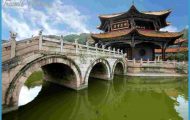
The capital Xi’an (see entry) and its surroundings offer countless sights. A visit is recommended to Yan’an (see entry), the birthplace of the Maoist revolution.
Shaanxi Map Photo Gallery


