
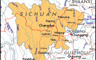
Autonomous Region
Area: 1,221,OOOsq.km/471,538sq. miles Population: 2,260,000. Capital: Lhasa
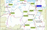
Tibet lies in south-west China, between longitudes 78° 25′ and 99° 06’E and latitudes 26° 44′ and 36° 32’N.
Tibet, or Bodjul in Tibetan, is China’s most thinly populated region, with the majority ofthe population – more and more of whom are now Chinese -living in the south ofthe country.
The very religious Tibetans profess Buddhism or Lamaism, a unique mixture of Indian Buddhism and animistic or magical beliefs. The spiritual and temporal head of state is the Dalai Lama (“Broad Sea of Knowledge”), whose succession is assured because Tibetan Buddhists believe that each Dalai Lama is a reincarnation of his predecessor.
The present head of state isthe 14th Dalai Lama (Tenzin Gyatso, b. 1935), who received the Nobel Peace Prize in 1989.
The whole territory occupies the barren Tibetan Plateau, known as the “Roof of the World” because of its average altitude of more than 4000m/13,000ft. The highest section is on the border with Nepal, and Mount Everest is, of course, the highest peak (8848m/29,039ft). This plateau, the highest and most extensive in the world, consists of almost uninhabited steppes and deserts in the west and north and the populated region in the south, in the relatively fertile mountain valleys (average 3900m/12,800ft), especially that of the Yarlung Zangbo Jiang (Brahmaputra) river, between the Trans-Himalayas and the Himalayas. The plateau is bordered in the north by the Kunlun Mountains, the highest peak of which is the Muztag (7723m/25,347ft).
In southern Tibet rise the rivers Indus and its tributary the Sutlej, the Yarlung Zangbo Jiang, Irawadi, Nujiang and Lancangjiang (Mekong); they all flow from west to east. The upper reaches of the Changjiang form the eastern border with Sichuan.
In 1993 the Chang Tang region in northern Tibet, an area of some 300,000sq.km/116,000sq. miles, was declared a national park-the second largest in the world.
Tibet has to endure an extremely harsh climate, although the sun shines quite often. Average temperatures vary between 23°C/73°F in summer and -15°C/5°F in winter. On the inhospitable Northern Plateau, however, where snow and sandstorms can often rage for weeks on end, the thermometer can fall to below -50°C/-58°F.
Topography
In the 7th c. a Buddhist kingdom was founded in Tibet, and this soon developed into a sizeable military power. In the 9th and 10th c. Buddhism was ousted and replaced by Lamaism, the spiritual leader of which also exercised temporal power over the people. Under the Mongolian Yuan dynasty (1271-1368) Tibet became a kind of vassal state. Chinese influence became evident from the 14th c. onwards. In 1642 the fifth Dalai Lama established a theocratic state. In the 18th and 19th c. the influence of the Chinese emperors increased. In 1903-04 a military expedition into Tibet led by the British officer and explorer Francis Edward Younghusband
Region within the Chinese People’s Republic. In 1966 and 1967 the Cultural Revolution made itself felt in Tibet also. The Red Guards prohibited any religious activity of any kind and destroyed almost all Tibet’s historical monuments, especially Lama monasteries; by the time these excesses, which cost the lives of countless Tibetans, finally came to an end a mere thirteen ofthe original 3800 or so temples and monasteries remained.
After 1976 the leadership in Beijing adopted a more liberal and pragmatic attitude towards Tibet and the region’s infrastructure benefited from the construction of a network of roads and the promotion of trade, commerce and industry (especially hydro-electric power, oil, precious metals and coal). In 1980 the Chinese introduced a programme of reform for Tibet, the main points of which were the reintroduction of religious freedom and the partial re-privatisation of agriculture.
Since 1987 there have been more and more demonstrations, particularly of monks and nuns, demanding Tibet’s independence; many have been forcibly suppressed by Chinese troops. In 1992, when the central government opened Tibet up to international trade and tourism, and again in 1993 the protests by the Tibetan people against Chinese dominance increased in number. However, China continues to refuse to grant sovereignty to Tibet.
Animal farming with yaks, goats, sheep, horses and donkeys is Tibet’s Economy main form of production. About a quarter of the people are nomads. The main agricultural products include barley (in the north this is grown on land as high up as 4600m/15,000ft above sea-level), wheat, pulses, fruit and vegetables. The industrial sector includes electric power stations, coal mines, engineering, building materials, chemicals, foodstuffs and timber. Xigaze and the capital Lhasa (see entries) are the major tourist centres. Places It is important that visitors are in good health (normal blood pressure, no to visit respiratory or heart problems). The high altitude soon affects those who are not used to it and who have come from countries which are not very high above sea-level.
Tibet Map Photo Gallery


