Bike: Tennessee Valley Beach is a good destination from other trailheads. Try taking a path off the Mill Valley-Sausalito bike route and then ride out Tennessee Valley Road and down the beach road. Start from Richardson Bayfront, TH21.
For a monster off-road ride from Tennessee Valley, try the Coastal Trail-Miwok Trail loop. This ride gains and loses more than 1,000 feet over a 5-mile course. From the Tennessee Valley parking area, roll down the main road 1.25 miles and veer right on the Coastal Trail. You climb steadily about 800 feet and steeply during the first part for the next 1.5 miles. The turn right, or east, on the Coyote Ridge Trail, climbing gradually to a summit at just over 1,000 feet during the next .75-mile. At the summit, the road hairpins back to your right, joining the meandering Miwok Trail on a very steep descent back to Tennessee Valley.
Two other mountain bike routes begin behind the Miwok Stables, near the parking lot, and head south out of Tennessee Valley. The Old Springs Trail goes due south up and down about 500 feet over a 2.5-mile course ending near Rodeo Lagoon at Fort Cronkhite. The Old Marincello Trail starts out eastward, but then hooks south and up, climbing about 600 feet, before gaining the ridge. The Old Marincello Trail joins the Bobcat Trail, which you can take down for 2 miles. Making a loop Marincello to Bobcat and then back on the Old Springs trail is a fairly strenuous 7-mile ride.
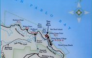
What’s Best: Take an exercise walk along Richardson Bay wetlands; or choose a bike ride toward all points on the compass in central and southern Marin.
Parking:From the north on Hwy. 101, take the Mill Valley-E. Blithedale exit. Turn right, or west, on East Blithedale, go about 1 ml, and turn left at traffic signal on Camino Alto Ave. From Camino Alto, turn left on Sycamore Ave. and continue .25 ml. Park at BayfTont Park. From the south on Hwy. 101, take the Hwy. 1-Shoreline Hwy. exit toward Stinson Beach. Proceed to traffic signal and turn right on Almonte Blvd, which becomes Miller Ave. From Miller Ave, turn right on Camino Alto Ave. and then right on Sycamore Ave. Agency: Mill Valley Parks & Recreation; Marin County Open Space District;
The Bayfront loop is a walk along the west shore of Richardson Bay and Mill Valley’s popular pooch park. Head toward the bay, staying to the left of the large lawn field that is surround by a low chain-link fence. Then turn right along the shore. At the far end of the dog park, the path curves to your right, and then comes to the multi-use path that leads back to the parking area.
For a power walk of Bothin Marsh, a Marin County Open Space Preserve, take the first part of the loop trail described above, or simply head out southbound on the multi-use path. Leaving Bayfront Park, you enter wide-open spaces of the marshland though Miller Avenue is not far away at times. You eventually come to the bay’s waters, under the Richardson Bay Bridge.
The Richardson Bay overlook is a scenic jaunt taken by few visitors. Go across the arched plank bridge, heading east over the creek that feeds the extreme north end of Richardson Bay. On the other side, at the south end of a rough-hewn field, make sure to head right on a path marked as Public Shore.
Travel to Tennessee Valley Photo Gallery


This path leads up a short distance through eucalyptus trees to a rock-walled overlook, with a tree-filtered look across the shallow bay. (The playground at Hauke Park on the left across the bridge is a winner.)
Bike: Richardson Bayfront offers many choices for cyclists wishing to explore southern Marin. For a Tiburon loop a ride of about 6 miles around Strawberry Peninsula head over the footbridge eastbound from Bayfront Park. Cross the park, to Hamilton Drive and turn right to Redwood Highway, a frontage road. Go south and take the pedestrian overpass over Highway 101; go left, or north, on the other side for a short distance and then right on Ricardo Road. From Ricardo make a right on Seminary Drive, which loops around the Golden Gate Theological Seminary along the shores of the Strawberry Peninsula. Bear left near the tip of the peninsula, where Seminary Drive becomes Strawberry Drive. After a mile, make a right on Harbor Cove Drive, going steeply downhill, behind a school. Turn right on Greenwood Beach Road. Greenwood takes you to the Tiburon Bike Path at Blackies Pasture, TH22. From Blackies, take the path all the way to Tiburon. To return, retrace your route through Blackies Pasture and Greenwood. Then go right to Tiburon Boulevard at Blackfield Drive. Ride west, crossing the car overpass at Highway 101. On the west side of Highway 101, Tiburon Boulevard is East Blithedale; continue a short distance to Camino Alto, where you turn left and take the multi-use path .25-mile to Bayfront Park.
To Sausalito, Fort Baker and Tennessee Valley, go south on the multi-use path from Bayfront Park. For Sausalito and Fort Baker, simply stay on the path, heading under the Richardson Bay Bridge and continuing to north Sausalito; See Marinship, TH19, to continue from there. Downtown Sausalito is about 4.5 miles from Bayfront; Fort Baker is just over 6 miles. To get to the beach at Tennessee Valley about a 10-mile round trip take an unpaved path to your right, after crossing a bridge a mile from Bayfront Park before reaching the Richardson Bay Bridge. This path follows a canal for less than .5-mile and then goes under two-lane Shoreline Highway on a low-clearance path. On the other side is Tennessee Valley Road. Trail fragments border the road during the first part, but you’ll wind up merging to the main road.
To hang out in downtown Mill Valley, without having to drive or park, pedal west on Sycamore, the street leading into Bayfront Park. Continue through neighborhood bungalows, about .5-mile to Park Street. You need to jog left on Park out to busy Miller Avenue for a short distance, and then jog right on Wood Street. From Wood make an immediate left on Presidio Avenue, which blends into Laurel Wood Avenue, as you take back streets into town. The flat, round-trip ride to Mill Valley is almost 3 miles.
To head to Corte Madera and Larkspur and from there to other central Marin destinations go north on the bike path and cross E. Blithedale. Continue on Lomita, the street below the bike path, up to the elementary school. Turn right, still on Lomita, and take it up to Horse Hill at Highway 101. Turn left here, and take the connector bike path along Highway 101, coming to Casa Buena Drive in Corte Madera. Continue to Tamalpais Drive. At Tamalpais, you can go left to Larkspur, TH50; or turn right, over Highway 101, connecting with Shorebird Marsh, TH27.