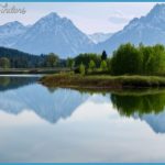
Far left to right: Three sharp peaks of the Absarokas poke above the trees: Grizzly, Doane, and Ste- To the south are the Tetons, 60 miles away. Flat Mountain at the southern edge of Yellowstone Lake. To the right and behind Flat Mountain, Mt. Sheridan, with its fire tower. Frank Island, Yellowstone Lake’s largest island, heavily burned in a 2003 fire, and Dot Island, with West Thumb Bay to its right. Behind and between the islands is high, flat Thorofare country. To the far right is Stevenson Island, the long, narrow one that can become two islands when water is very high in the lake. 16.3/9.7 S© Lake Butte side road to the north, about 0.8 mile (1 km) to a pretty view. The butte is the most westerly peak of Absaroka Volcanics in this part of the park. The panoramic view from the top of this road takes in more of Yellowstone Lake and distant mountains than you can see from any other road in the park. The view stretches (right to left) from the white Sulphur Hills above rounded Mary Bay and the hydrothermally altered rocks of Steamboat Point to the northwest, through the distant Gallatin Range in the northwestern corner of the park, across the Yellowstone caldera to the west, to the mountains near the southern arms of the lake and to the faintly visible Tetons.
17.0/9.0 (S Nine Mile Trailhead for the Thorofare Trail on a short side road to the south. This is a long pack trail that parallels the lakeshore to the park’s Thorofare corner. The southeast area ofthe park is called the Thorofare. The name dates from the fur-trading days of the 1820s and 1830s, when the only known southern route into the Yellowstone Plateau was by way of Two Ocean Pass and down the Yellowstone River. Today the Thorofare patrol cabin has the distinction of being the place farthest from a maintained road in the contiguous United States. Between here and Butte Springs, we cross into the Yellowstone caldera; here the caldera rim runs approximately northeast-southwest. Fire damage from 2003 ends near Butte Springs.

