
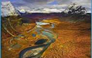
The Hardangervidda is a plateau (area c. 7500 sq. km 2900 sq. miles) lying at a height of between 1000 and 1400 m (3300 and 4600 ft), with many lakes and a meagre covering of pasture which provides grazing for large herds of wild reindeer. There are also about a hundred hill dairy farms in the region. The scenery of the Hardangervidda, above the tree-line, is barren and desolate but very impressive. There are plans to establish a National Park with an area of 3200 sq. km (1235 sq. miles). Five other areas are to be made nature reserves.
This is magnificent walking country, with an extensive system of paths, usually running from one lake (well stocked with fish) to another and linking the numerous mountain huts (usually overcrowded during the height of the season, from 15 July to 15 August). In the interior of the
Hardangervidda there are no motor roads or settlements of any size.
The best means of access is Road 7, from Geilo (116) to Eidfjord, which separates the Hardangervidda proper from the Hardangerjokul, a snowfield covering 120 sq. km (46 sq. miles) (highest point 1862 m 6109 ft) rising to the N of the road and also accessible on the N from the Bergen railway. Road 7 climbs from Haugastel (alt. 990 m 3248 ft) to reach its highest point at the Dyranut mountain hut (1246 m (4088 ft): 40 b.) and then runs down into the valley of the Bjoreia. 20 km (12 miles) beyond Dyranut a narrow road (toll) branches off and runs 1 km (J mile) N to the Fosslihotell (alt. 729 m 2392 ft), in a commanding setting above the precipitous Mabodal. From here there is a magnificent view of the Voringfoss, where the Bjoreia plunges vertically 183 m (600 ft) into a narrow rock basin, always filled with a dense mass of spray (marvellous play of colour, particularly in the afternoon). The Fosslihotell is a good base for mountain walks and climbs. Especially rewarding is the long walk (13-14i hours) by way of the Demmevass hut (1280 m 4200 ft), on the western edge of the Hardangerjokul, to Finse (1222 m 4009 ft; mountain hotel) on the Bergen railway (highest station in the country), located on the Finsevann in a lonely mountain region.
Beyond the turning for the Fosslihotell the finest and most interesting stretch of Road 7 begins, down the wild Mabodal, throughtunnels, along almost vertical rock faces, and finally descending in five huge bends to Mabo (alt. 250 m 820 ft), where it reaches the Eidfjord (1 24).
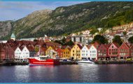
On the W the Hardangervidda falls steeply to the Sorfjord (124), along the E side of which runs Road 47. The road nearest to it on the S side is the Haukeli Road (266).
Hardangervidda Norway Map Photo Gallery
