
STRENUOUS KABETOGAMA PENINSULA VOYAGEURS NATIONAL PARK
LENGTH 9.9 miles
TIME 8:30
DIFFICULTY Strenuous
ROUTE-FINDING Easy-Moderate. There are trail maps at most intersections, and rock cairns to mark the way across rock outcroppings.
MAPS & PERMITS MacKenzie K1-Kabetogama. USGS quad: Ash River NE. No permit is required.
GETTING THERE From the Ash River Ranger Station, paddle due north and enter the small channel leading to Lost Lake. Make the quarter-mile portage to Long Slu and paddle to Lost Bay. Turn right and continue to the head of the bay where you will find a dock and the trailhead.
TRAILHEAD GPS 48 ‘ 27′ 56.9″ N 92= 49’ 13.4″ W
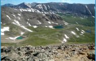
The Kabetogama Peninsula offers limited hiking opportunities, but what is lacking in quantity is more than made up in quality. This hike offers extensive panoramic views of lakes, beaver ponds, stream valleys, and a major bay on Kabetogama Lake. Well-constructed bridges and boardwalks keep hikers dry where the route crosses streams and low-lying wetlands. Although the almost ten miles of hiking and ten miles of paddling sounds challenging, experienced hikers and canoeists should be able to easily finish it in a day. If hiked in the summer, when the days are longest, there should even be enough time to relax at Cruiser Lake or one or more of the many overlooks. If you think the full 9.9 mile hike is too long, consider doing the shorter 3.4 mile hike without the walk to Cruiser Lake. The circuit alone is still an excellent hike.
The canoe route to the trailhead from the Ash River Ranger Station lies across protected waters for the most part. However, there are some stretches of open water where the wind can kick up rough waves. Paddling these stretches after completing a strenuous ten-mile hike will make the going that much more difficult. A motor boat would make the trip to and from the trailhead quicker and easier. But, the slow, quiet pace of the canoe sets a good mood for the hike, and is a unique vantage point from which to reflect on the beauty of Voyageurs National Park.
The Kabetogama Peninsula is 75,000 acres of ridges, lakes, streams, beaver ponds, bogs, meadows, and not a single road. Surrounded by Rainy Lake to the north, Kabetogama Lake to the south, and Namakan Lake to the east, the peninsula has seen many changes. The pink vermilion granite bedrock that forms many of the ridges is over 2.5 billion years old, and dates from a time when the North American continent was formed. This granite is part of a giant batholith that was once the core of a mountain range. Erosion has worn the mountains down over time, and glaciers have scoured the bedrock. Grooves in the hard rock made by the boulder-wielding ice sheet give an indication of the tremendous erosive power of glaciers.
Best travel destinations in US Photo Gallery

