
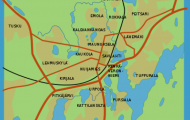
Province: Norrbottens Ian. Region: Lapland. Altitude: 359 m (11 78 ft). Population: 25,000. Postal code: S-97200. Telephone code: 0970. Gallivare TuristbyrS (March-August), Lasarettgatan 14; tel. 1 36 30.
HOTELS. Dundret, 20 Polar, 80 Vassara, 83 Vietas Turistanlaggning (STF), 40 Satoluokta Fjallstation (STF), 87 b. Holiday villages of Dundret and Tjuonajokk (anglers’ camp). YOUTH HOSTEL. CAMPSITE.
The town of Gallivare in northern Sweden owes its existence to the local deposits of iron ore. It lies on the Vasarajarvi (Hammer Lake), 70 km (44 miles) INI of the Arctic Circle. The midnight sun is visible here from 2 June to 12 July.
ACCESS. Gallivare can be reached either on Road 97 via Jokkmokk (96 km 60 miles), which passes the Muddus National Park (to E) and continues via Porjus, at the southern ti p of the Stora Lulevatten lake; or from Lule§ on E4 to Tore (54 km 34 miles), then on Road 98 to Overkalix (51 km 32 miles), from which it is another 128 km (80 miles) to Gallivare.
The deposits of iron ore round Gallivare have been known since the 18th c. A British company began to work them in 1869 and built a railway line to LuleS in 1 884. Six years later it sold the workings to the Swedish government, which in 1957 also took over another private mining company, the Luossavaara-Kiirunavaara AB (LKAB). The reserves of ore are estimated at 400 million tons, with an iron content of 62-70%. Oniy in high summer can the ore be exported from LuleS; during most ofthe year it is carried by train through Kiruna on the iron-ore railway to the ice-free Norwegian port of Narvik; only a small proportion is processed in Lulel by the Svenska Stal AB, another state-owned company associated with LKAB, or in other Swedish steelworks.
SIGHTS. There is a romantic wooden church (1881), known as the one ore church because every taxpayer had to contribute one ore towards its cost. Lapp boarding school (used in summer as a youth hostel); in the upper classes ofthe secondary school there are special subjects for Lapps.
SURROUNDINGS. 5 km (3 miles) SW is the hill of Dundret (823 m (2700 ft): magnificent views), with the Dundret recreation area. The hill can be climbed in 1 i to 1 i hours (hut); attractive skiing spot. 6 km (4 miles) N is the ore mountain of Malmberget, with three peaks, Valkomman (617 m 2024 ft), Kungsryggen (580 m 1 903 ft) and Kaptenshdjden (518 m 1700 ft). From the mining settlement of Malmberget (Malm Hotell, 46 b.) at the foot ofthe hill there are beautiful views towards Dundret. All Saints Church (1 944) had to be moved some years ago, since it was in danger of sinking into a mine shaft. The altarconsists of a block of Malmberg ore. In the LKAB offices is a mining museum. Visits to the workings (c. 250 km (150 miles) of underground galleries and tunnels) can be arranged. 4 km (2 miles) NE of Malmberget are the Koskulskule iron-mines.
Gallivare Sweden Map Photo Gallery


