
County: More og Romsdal fylke.
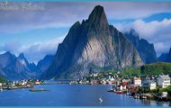
The Geirangerfjord and surrounding area offer some of the finest scenery in the whole of Norway. The fjord isthe eastward continuation of the Sunnlyvsford, which in turn branches off the Storfjord. The shores of the Geirangerfjord are notable for their numerous waterfalls and beautiful views.
The narrow and winding road to the village of Geiranger at the head of the fjord turns N off Road 1 5 (Gudbrandsdal to the Nordfjord) to the W of Grotli.
Grotli (alt. 870 m (2854 ft); Hoyfjells-hotell, 1 07 b.), an important road junction, frequently has snow until well into the summer. Some 15 km (10 miles) W of the town the Geiranger road (No. 58) turns off. The first stretch of the road runs through bare mountainous country on the northern shore of the Breidalsvann (alt. 880 m 2887 ft), which is enclosed between the Breidalsegga on the N and the Vassvendegga on the S, and then skirts two smaller lakes (on left). After 1 8 km (11 miles) the road passes, also on the left, the Djupvann (1 004 m 3294 ft), which is frequently frozen until August, and in another 2 km (1i miles) comes to the highest point on the road (1 038 m 3406 ft), which is open for traffic from 1 June to 1 5 October. On the S side of the lake are the sheer rock faces of the Grasdalsegga (1 570 m 51 51 ft). At the W end of the lake is the Djupvashytta hotel (1020 m (3347 ft); 30 b.), which is frequented by summer skiers (ski race at end of June).
Here the road known as the Nibbevei (normally open 1 June to 1 October; toll) branches off on the right and climbs (5 km (3 miles); gradients up to 12-5%; 10 hairpin turns) to the summit of the Dalsnibba (1495 m 4905 ft), from which there are superb’views of the mountains and the Geirangerfjord far below.
Soon after Djupvashytta, beyond the watershed between the Skagerrak and the Atlantic, an impressive stretch of mountain road begins. The road to Geiranger (opened 1 885) descends some 1 000 m (3280 ft), with gradients of up to 8%, 20 sharp turns (some of them very narrow indeed) and several bridges, to reach Geiranger in 1 7 km (10 miles) (distance as the crow flies 7 km 4 miles). Travellers on this road experience a sudden transition from the severe climate of the mountain regions to the warmer and milder air of the sheltered valley. 2 km (Hmiles) along the road, on the left, is the Blafjell, with the Jettegryte (Giant’s Pot), a cavity 2-2 m (7 ft) across and 9-5 m (30 ft) deep gouged out by glacier action.
Beyond the Qvre Blafjetlbro (bridge) there is a magnificent view: to the left the Flydalshorn, to the right the Vindashorn, beyond it the Sathorn (1779 m- 5837 ft), and the Grindalshorn (1 534 m 5033 ft), and straight ahead the Eagles’ Road which winds its way up from Geiranger to Eidsdal. The road crosses the Nedre Bla-fjellbro, with the falls on the Kvandalselv
The Eagles’ Road runs from the Geirangerfjord to the Norddalsfjord. It climbs with eleven hairpin turns, with beautiful views of the fjord and the waterfalls, to Korsmyra (624 m 2047 ft), where the road reaches its highest point, and then descends past the Eidsvann to Eidsdal on the Norddalsfjord, a village with woodworking and clothing factories and an octagonal church of 1 782. Ferry to Linge, on the N side of the fjord, from which Road 63 runs W to Alesund (57) and E to Andalsnes (226).
The Geirangerfjord from the Flydal gorge to the right, and then descends into the next stage of the valley, the Flydal: to the left the Flydalshorn, to the right the Bighorn (1738 m 5702 ft). Beyond Qrjeseteristbe Flydalsjuv (300 m 330 yds), a gorge from which there is another superb view (parking place). From Hole, a short distance beyond this, a rewarding detour can be made to Vesteras and from there on a marked footpath to the Storseterfoss, a waterfall 30 m (1 00 ft) high. The main road continues to the Utsikten Bellevue Hotel (72 b.) and beyond this (on left, before a bridge) a standing stone commemorating the adoption of the Norwegian constitution of 1814.
Geiranger (Union Turisthotell, 250 Geiranger Hotell, 1 51 SP; Meriks Fjord Hotel, 63 Grande Turistheim, 27 several camp sites) is a popular little tourist resort and port in a beautiful setting at the E end of the Geirangerfjord.
During the season very attractive sightseeing cruises by motor-ship (2 hours) are run several times daily, giving visitors an excellent opportunity of seeing the impressive scenery of the fjord, with its sheer rock walls and numerous waterfalls. High up on the left can be seen the abandoned farm of Skagefla; then on the right the Syv Sestre (Seven Sisters) waterfall, which forms seven separate falls when it is swollen by melt-water in spring. To the left of this is the Friar (Suitor), to the right the Brudesler (Bridal Veil). To the W the Geirangerfjord runs into the Sun-nylvsfjord, to the S of which is the village of Hellesylt (ferry to Geiranger); at the N end of the fjord, on the left, is Stranda.
From Geiranger Road 58 runs along the N side ofthe fjord, coming in 3 km (2 miles) to a group of houses over 200 years old, Mellgardene, the starting point of the Eagles’ Road.
Geirangerfjord Norway Map Photo Gallery
