
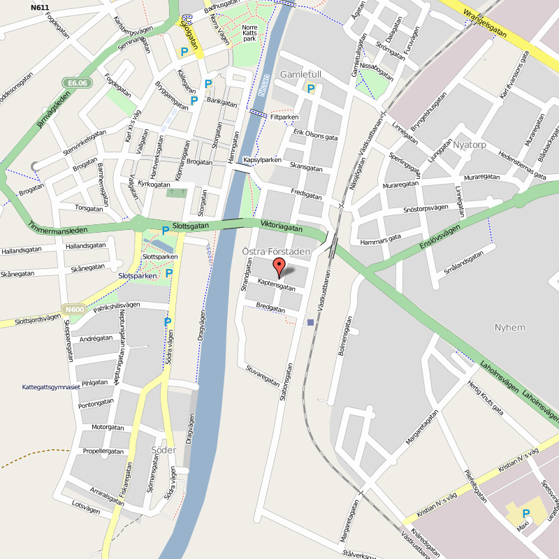
Province: Hallands Ian. Region: Halland.
Altitude: sea level. Population: 75.000.
Postal code: S-30590. Telephone code: 0 35.
Osterbro;tel. 11 15 81 and 11 75 42.
Branch office (May-September),
Ostra Stranden; tel. 11 35 41.
HOTELS. Hallandia, Radhusgatan 4, 180 b.: OK Motor Hotel, Strandvallen 3, 122 SP: Hotell Martenson, Storgatan 52, 130 Harmonia, Norra Vagen 7, 58 b.: Sara, Kaptensgatan 12, 30 b. in tylosand (9 km (6 miles) W, on the coast): Tylosands Havsbad, 228 SB; Snackan, 40 b. Three CAMPSITES.
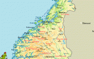
Halmstad, main town of the Swedish province of Halland, lies near the outflow of the River Nissan into Laholm Bay. This situation promoted its rapid development into an important trading town and port. The town received its municipal charter in 1307. After a fire in 1619 it was rebuilt, and the old town has preserved much of the appearance of that period.
Tourism, particularly in the summer months, is now making an increasingly important contribution to the town’s economy. The seaside resort of Tylosand, 9 km (6 miles) W, is one of the most attractive in Sweden, with long sandy beaches.
SIGHTS. The market square (Stora Torg) is dominated by a fountain by Carl Milles (1875-1955), Europa and the Bull. On the S side of the square stands the Town Hall (1938). The interior is decorated with intarsia work (mosaic woodwork) by the Halmstad-Group, an association (established 1929) of six painters, mostly from Halmstad, who became known outside Sweden as the
Swedish surrealists. The carillon plays at 8 a.m. 12 noon and 6 and 9 p.m. and at the same time the four groups of figures below change places. Adjoining the Town Hall is an old half-timbered building, once used as a hospital. Here, too, is St Nicholas’s Church (14th c,), with a fine exterior. Beyond the Town Hall stands the old Castle (early 17th c.), now the governor’s residence. On its seaward side is moored Najaden, a sailing vessel (built 1897) used as a training ship. On the banks of the Nissan is a 14 m (45 ft) high sculpture by Picasso, Woman’s Head, set up in 1971. From the market square Storgatan runs N to the Norre Port (1605), at the S end of the Norre Katt Park. This is the only surviving town gate belonging to the old fortifications, most of which were pulled down in 1734 by order of the town council. To the N ofthe park in the Halland Museum there is an interesting section on ships and the sea. N ofthe town is the wooded Galgenberg, with a lookout tower and an open-air museum, Hallands Garden (old houses, School Museum).
SURROUNDINGS. 9 km (5 miles) W is the well-known resort of Tylosand. The road to it runs past the Miniland leisure park, with scale models (1:25) of 30 of Sweden’s principal sights, surrounded by beautiful gardens (May-September). St Olof’s Chapel (18th c.), originally in SmSland, was demolished in 1879 and re-erected in Tylosand in 1949-50. 16 km (10 miles) N of Halmstad on the coast road is Haver-dalsstrand nature reserve (area 350 hectares 800 acres), with a sandy beach 4-5 km (3 miles) long and unusual dune formations. From here the road continues to Ugglarps (Motor Car and Aircraft Museum, open June-August) and Falkenberg (24 km 15 miles).
E6 leads N from Halmstad through partly wooded and gently rolling country. In 13 km (8 miles) it comes to Kvibille church (on right), which dates in part from the 13th c. (restored 1670 and 1949-53). 3-5 km (2 miles) beyond this, to the right of the road, stands the manor-house oiFrdlinge (main building 1623). Then via Skrea (18 km 11 miles) to Falkenberg (pop. 34,000; Grand Hotell, 80 MHF-Motellet Tre Hastar, 125 Strandbaden, 142 Skrea Motell, on E6, 32 youth hostel; three camp sites), located at the outflow of the Atran, a river well stocked with salmon (fishing permitted 1 March to 7 August), into the Kattegat. The first mention of the town dates back to medieval times. St Lawrence’s Church (partly dating from the 12th c. with fine ceiling and wall paintingsfromthe 17thand 18thc.) isstillsurrounded by many wooden houses from the 18th and 19th c. The Town House was not completed until 1959; the old toll bridge dates from 1756, the Town Hall from 1830. The Torngrens pottery establishment in Kruk-makeregatan has been operating since 1786, and still belongs to the same family. There are only scanty remains of the old castle which was destroyed in 1534 by Engelbrekt and his peasant army. Falkenberg has a sandy beach 8 km (5 miles) long; sea-fishing trips from the harbour.
To the S of Halmstad E6 also follows the coast, but the inland route on Road 117 holds great attraction. 13 km (8 miles) S of Halmstad, at the estate oiStFladje.a side road goes off on the left (1 km (£ mile) E) to the 12th c. Romanesque church of Eldsberga, beyond the railway line; old wall paintings were discovered here in 1976. Many Bronze Age tombs, often set on hills commanding good views, can be seen in the surrounding area. The main road comes in another
10 km (6 miles) to Laholm (pop. 20,000; Stadshotel-let, 22 camp site), an old town on the River Lagan where life still moves at a rather deliberate pace. It is noted for the numerous works of art in its streets and squares, including a fountain with a sculpture by the Italian Luciano Minguzzi. This commemorates the work for peace of Count Folke Bernadotte (1895-1948), Dag Hammarskjold (1905-61) and President J. F. Kennedy (1917-63). The Horse Fountain in Hasttorg (Horse Square”) and the Laga Fountain (by John Lundqvist) in the Stora Torg are also notable. On the S gable of theTown Hall (18th c.) mechanical figures perform a jousting scene daily at
12 noon and 6 p.m. Beside the Castle (17th c.) is a salmon hatchery. 6 km (4 miles) up the Lagan is a 15 m (50 ft) waterfall, the Karsefors (power station). 6 km (4 miles) W the seaside resort of Myllbystrand (Motell HallandsgSrden, 48 camp site) has a sandy beach 12 km (7 miles) long.
From Laholm the road continues S for 13 km (8 miles) to Ostra Karup (Hallandsas Motell, 51 b.), where it joins E6. 4 km (2£ miles) E, near Hassov church, is a Bronze Age burial mound, Lugnarohogen (open to the public). We have now left Halland and entered Sk§ne. From here Road 115 runs 8 km (5 miles) W to the popular resort of BSstad, at the S end of Laholm Bay (Hemmeslovs HerrgSrdspensionat, 300 SP, open Easter to August; Hotel- Pension Enehall, 120 open May-September; Hotel BSstad, 48 Malens Havsbad, 260 SP, open June-August). Located on the northern slopes of the HalandsHs hills, it is noted for its mild climate. St Mary’s Church dates from the 15th c. but much of it was destroyed in a great fire in 1870. There are numbers of well-preserved old houses in the town. 4 km (2 miles) W is Norrviken, with beautiful gardens.
From Bastad the route continues on Road 115 via Hov to Torekov (Hotel Kattegat, 17 campsite), a fishing village which is also a popular seaside resort. Offshore is the little island of Hallands Vaderd, reached in 30 minutes by boat, which has an abundance of bird life.
The road now turns inland through gentle, fertile country to Forsldvshom and continues S to Skalder-viken, a little resort in the bay of the same name on the Kattegat. 2-5 km (11 miles) before the town we find Barkakra church (late 12th c.). 5 km (3 miles) farther on is Angelholm (pop. 29,000; Hotell Continental, 40 Angelholm Motel, 30 camp site), near the outflow of the RonneS into the Skaldervik, which has preserved the atmosphere of a small country town (18th c. town hall). It is now primarily a vacation resort, located 3 km (2 miles) from a beautiful sandy beach. From the S side of the bay there is a view of the Kullen range of hills.
Halmstad Sweden Map Photo Gallery

