
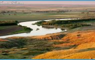
The Blackfoot backroad starts just east of Missoula, at a site that exemplifies this landscape’s remarkable evolution from pristine to despoiled to pristine again. On the south side of Interstate 90 at Bonner (pop. 1,663), where the Blackfoot empties into the Clark Fork River, is a wide plain of stumps, gravel, and debris, with a river running through it. A few years ago, a small reservoir backed up behind the Milltown Dam here, accumulating mining toxins that arrived from more than 100 miles upstream at the Warm Springs Ponds near Butte and Anaconda.
The Milltown Reservoir complex was the largest federal Superfund site in the West due to arsenic contamination traced to as far back as a 1908 flood that spread through the years. Cleanup was made a priority in the early 1980s and the results are right before your eyes: The removal of the 100-year-old dam in 2008, the disposal of more than 3 million tons of contaminated sediments, and the restoration of natural flow and vegetation to the Clark Fork River. It’ll be many years before the area around the confluence of the Blackfoot and Clark Fork returns to its pre-industrial look, but one day the only evidence of Milltown’s toxic history will be spelled out on interpretive kiosks in the Milltown State Park, which opened in 2014.
In many ways, Bonner epitomizes the region’s evolution. Once a logging town with a humming plywood mill, the community is exploiting its prime location as a recreation gateway to the Blackfoot country. Stop at Two Rivers Memorial Park next to the MT 200 Blackfoot River bridge and call ahead for a tour of the Bonner Milltown History Center & Museum (406-258-6335) to get a close-up peek into a rich history.
As you work your way out of town, you’ll see more of the old and the new. The massive mill sold in 2008 and is being revamped to an industrial park with several businesses, including an aluminum trailer manufacturing facility. The new owners also bought the row of 120-year-old company-town homes on the northeast edge of town, with plans to restore and rent them
Heading out of Bonner on MT 200, you’ll meander through a pretty canyon with slopes blanketed by ponderosa pines. Look for bighorn sheep that come out of the hills for Blackfoot water. There are several campgrounds and river-access points for floaters along the way. Around mile post 12, look carefully for the hand-painted signs pointing over the creek and through the woods to Steel Toe Distillery (406-244-4567, Wed.-Sun 12-7 pm), where you can sample their whiskey and gin. At the little wayside of McNamara Bridge, Blackfoot River Rentals (406-244-0404) has rafts and tubes for floating the river, and also provides shuttle service. Here’s where you’ll need to make a decision: Continue on MT 200 for a more expedient drive through pastoral ranchlands or turn left onto the dirt and gravel Johnsrud Park Road (and eventual Ninemile Prairie Road) to stay with the Blackfoot for about 18 miles (see Side Tracks) until you rejoin the main highway at Greenough. The benefits: This is the photogenic Blackfoot of postcards and brochures, the ultimate destination for many anglers and floaters, especially fanatics of splash-and-giggle Class II-III whitewater. The downside: You’ll miss Potomac, home to Cully’s Bar & Grill (406-244-3100), a Blackfoot Valley fixture that reigns as the valley’s top watering hole (see Best Bar).
The Big Blackfoot
Greenough (pop. 250) had its brush with royalty literally in 1992 when the U.K.’s Prince Charles and Princess Diana sent their 10-year-old son, William, to the rustic E Bar L Ranch to give him a break from the attention surrounding their divorce. Owners of the guest ranch said William had a marvelous time until British tabloid media discovered his whereabouts, forcing him to flee again. The E Bar L (see Lodging) is more noteworthy locally for its conservation ethic, which provided the first roots for The Blackfoot Challenge project.
At Greenough, look for Garnet Range Road, which provides twisting, winding access to Garnet Ghost Town high in the Garnet Range to the south (see Side Tracks). Garnet is considered one of the two or three best examples of an intact ghost town in Montana, thanks largely to a preservation group from Missoula. Speaking of Missoula, less than a quarter-mile past Garnet Range Road and Mile Marker 22 is the turn for the University of Montana’s 28,000-acre Lubrecht Experimental Forest
(406-244-5524), an outdoor classroom for forestry and conservation students. It’s a great place to learn about modern management of forests. Or stay overnight (see Alternative Bunking) and enjoy outdoor recreation, including fishing the Blackfoot, hiking, and skiing amid the pines on trails maintained by the Missoula Nordic Ski Club. For a far swankier experience in the Blackfoot, the sprawling and elegant Paws Up Resort (see Lodging) seems almost out of place, with its upscale log homes, spa, a restaurant with an executive chef, Wine Spectator Award of Excellence, and other all-inclusive amenities befitting Jackson Hole or Sun Valley.
SIDE TRACKS
Johnsrud Park Road/Ninemile Prairie Road (18 miles)
To fully understand why the Blackfoot River is so popular, pack a picnic, veer off MT 200 at McNamara, drive the gravel road to Barite, and watch floaters or fishers ply revered waters. The entire 18-mile drive through what is known as the Blackfoot River Recreation Corridor is scenic, but the best stretch for pulling over to watch rafts, kayakers, and tubers navigate Class II III whitewater is in the first six miles after the turnoff.
Though there are eight boat launches in this short stretch, many rafters, kayakers, driftboaters, and tubers launch at Whitaker Bridge and take out at Johnsrud, ensuring they get to navigate Thibodeau Rapids, the river’s most popular whitewater. Fishermen love this stretch, too, because the trout aren’t as finicky as they are in some of the more placid waters of the Blackfoot above and below this canyon stretch. Despite the presence of recreationists, you’ll feel as if you’ve entered wild country. It’s a world of whitewater, cliffs, and ponderosa pines that goes right up to the river’s edge a distinct change from the beautiful but wide-open valley dotted by ranches and small communities on MT 200.
MONTANA TRAVEL GUIDE 2017 Photo Gallery


