
What’s Best: A large marsh preserve hiding in plain sight along the urban corridor of central Marin with paths along the San Francisco Bay and views of Mount Tam.
Parking: Take the Tamalpais Dr.-Paradise Dr. exit from Hwy. 101 in Corte Madera and go east on Tamalpais Dr, toward the bay. Park near corner of Tamalpais and Paradise; or, at The Village shopping center. Turn left at signal on Redwood Highway and make first left into the The Village. Agency: California Department of Fish and Game; Corte Madera Parks Department Shorebird Marsh is comprised of several wetlands, the largest of which is Corte Madera Marsh, a state ecological preserve. The Corte Madera Creek enters the bay at the north side of the marsh, site of the Larkspur Ferry Terminal so walks on the marsh usually include views of ferries offshore heading to and from the City. On the south end of the wetland is San Clemente Creek. The inland area of the marsh supports stands of pampas grass, and along portions of the paths are acacia trees, blooming yellow in late winter. A variety of birds roost on the high wires hung between huge power towers. Eastward, across open water is “The Q” San Quentin State Prison.
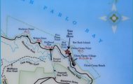
SHOREBIRD MARSH MAP SAN FRANCISCO Photo Gallery

For the Corte Madera Marsh loop, take the crosswalk at the corner of Tamalpais and San Clemente. Pass the first unpaved road that borders a canal and then walk left on a second, which you come to shortly thereafter. The route heads toward the bay and then back left, or north, encircling the entire wetland. On the northeast sector of the loop, a spur trail leads out to the mouth of Corte Madera Creek, close to passing ferries. To walk Muzzi Marsh, a smaller preserve bordering San Clemente Creek, take the paved bike path to your right after crossing the crosswalk at the southeast corner at The Village parking lot. After a short segment that parallels busy San Clemente Drive, you turn left. The unsigned path to Muzzi Marsh heads eastward off the bike path. You can walk straight out to the mouth of the creek, or use another levee path to make a loop out of it.
Shorebird Marsh Park has no hiking trails, but its lagoon is a popular spot for migratory birds and waterfowl and for stationary brown-baggers taking a lunch break. The small park is located just north of The Village on the Redwood Highway frontage road. Shorebird Marsh lies just east of the lagoon, creating a mile-wide backdrop. The park is next to the freeway, so noise is a factor.
Bike: Aside from being a pleasant pedal, Shorebird Marsh is a convenient central departure point for many destinations around Marin. To go north to Larkspur Landing, TH29, take the bike path going north across from The Village. Continue past Shoreline Park, skirting busy Redwood Highway. After passing the pedestrian overpass, look for an opening in the fence to your left, and take the elevated sidewalk north over a freeway off-ramp. At the other end of the ramp, which is Sir Francis Drake Boulevard, is the Corte Madera Creek bike path. From this path you can either head west toward Kentfield or east on the scenic route to San Rafael; see, TH28-29.
To Larkspur, head north on the bike path, past Shorebird Park, and turn left on the Wornum underpass. Continue across Vista Boulevard after crossing under Highway 101. Follow a bike path through a greenbelt that heads right at Mt. Tam. Turn right when you reach a canal, toward nearby Lucky Drive. At Lucky, go left behind Redwood High School on a path that leads to the old railroad easement behind Larkspur. A bridge over the canal at Wornum is a scenic shortcut on this route.
To Mill Valley from Shorebird Marsh, head west on Tamalpais Drive, crossing Highway 101 on the elevated sidewalk. On the other, cut left across busy Tamalpais and keep left, following Casa Buena Drive south, over Horse Hill, to Richardson’s Bayfront; see TH21. To Tiburon from the marsh, take the bike route south, along San Clemente, and then go left on Paradise Drive. You then climb on curving Paradise Drive and come to Trestle Glen Boulevard. Turn right on Trestle Glen and drop down to Blackies Pasture on Tiburon Boulevard. A bike path leads from Blackies into Tiburon; see TH22.

