
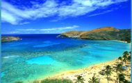
The Missouri River is most responsible for this spectacular rock sculptures in the White Cliffs and badlands areas. For it was the river that cut through alternating soft shale and hard sandstone, creating an array of tall, thin, and eerie rock features called hoodoos and crops of pedestal rocks that look like toadstools. Montanans have an abiding affection for this arid area, and a journey in a river craft is a popular pastime.
Though the Missouri Breaks Backcountry Byway can be reached from US 191, begin your trip in Winifred, a proud and tight-knit gateway to the region and a necessary stop to appreciate local history and culture. The Winifred Museum has the requisite assortment of historical homesteader, Indian, and dinosaur artifacts, but the primary reason to stop here is for what the town claims and after seeing it, who’s to doubt? to be the largest collection of Tonka trucks anywhere. The museum is open only in summers, but if you’re there during the off-season give them a call and they’ll gladly come by and open up.
Winifred is also the only place on the route to grab a bite to eat, either at the Winifred Tavern & Cafe or Trails Inn Bar both of which serve what you’d expect in rural Montana and you can gas up at the Cenex. The historic building that houses the Winifred Grocery underwent renovations that stayed true to character, dating to when it was known as Stafford’s. You’re in the middle of nowhere here, but the grocery has purchased a cell-phone range extender so townies and out-of-town customers alike can now make calls, text, or use the Internet.
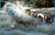
As you drive about a mile east from Winifred on Knox Ridge Road to begin the byway, go off the beaten byway about 12 miles to the free McClelland Ferry, one of three left crossing the Missouri. The McClelland Ferry, also called the Stafford Ferry, is nearly a century old. Make the detour just to experience a vanishing piece of frontier history and talk to the operators of the diesel-powered craft.
Back at the junction near Winifred, head east again and drive another 11 miles to the next junction: Two Calf Road. Here begins the byway loop. The more improved Knox Ridge Road continues to the east; the more scenic but slower Two Calf Road route goes north and eventually reaches the rim above the Missouri. If you’re feeling especially adventurous, take some of the two-track trails veering off toward the rim for some spectacular views of the river, distant mountains, and a look at geologic history, peeled away one era after another in the cliffs. Fourteen miles into Two Calf Road is the Woodhawk Trail, which leads to a dramatic overlook. Continue another 2 miles on Two Calf Road, and you’ll reach Woodhawk Bottoms Road, which leads down to the river. Two miles beyond Woodhawk Bottoms Road is Power Plant Ferry Road this one to the site of an old ferry, the only crossing in the area until Fred Robinson Bridge on US 191 was built. And that isn’t the last road to the Missouri: five miles beyond Power Plant Ferry Road is 2-mile-long Heller Bottom Road, which might be the most scenic of the bunch.
About 30 miles into the northern route is the western end of the 125-mile-long, 1.1-million-acre Charles M. Russell National Wildlife Refuge, a small portion of which is west of US 191. The refuge was created in 1936 to preserve habitat for the pronghorn and sharp-tail grouse. Some 60 mammals and 220 bird species are here year-round, and if conservationists have their way, there’ll be one more mammal the bison.
The byway loop roads reconnect about 5 miles west of US 191. The return 23-mile trip across sage plains will surely be quicker, but take your time even though you’re away from the river there’s still plenty of wildlife to see.
The Missouri River Map Photo Gallery
