
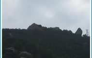
The casual tourist driving through the middle of the Uwharrie Mountains might be forgiven for asking where they are. At a maximum elevation of just over one thousand feet and projecting only a few hundred feet above the surrounding land, the Uwharries look nothing like their neighbors to the west, the Appalachians. At one time, it was believed the Uwharries might be the oldest mountain range on the continent, but geologists today tell us that they are mere babies at around 18 million years old (the Appalachians are around 300 million years old). Actually, the Uwharries aren’t even technically considered mountains. They are the hard-rock remnants of an eroded flat plain, called a peneplain.
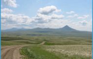
Our route takes us through open, rolling, agricultural lands and deep within hardwood forests. At the beginning of the route, New Hope Road and High Pine Church Road offer the finest pastoral views in the Uwharries. The road crosses Uwharrie River just downstream and out of sight of Lassiter Mill, one of the few remaining gristmills in a region once filled with them. At the crossroads up from the river, a left turn takes you into the Birkhead Mountain Wilderness Area and some of the best hiking trails in the Uwharries.
The pastoral landscapes in the Uwharrie Mountains region become especially scenic at sunrise.
Coneflowers complement a summer view of Pisgah Covered Bridge, one of only two remaining covered bridges in the state.
Continue straight from the crossroads and in a few miles you cross the West Fork of Little River at Pisgah Covered Bridge. Of the hundreds of covered bridges that once spanned North Carolina’s waterways (as many as sixty in Randolph County alone), Pisgah is one of only two remaining. An easy loop path winds through the forest downstream from the bridge and provides up-close views of the abundant mountain laurel shrub, a plant more at home in the western North Carolina mountains than here in the Piedmont.
Shortly after turning off Horseshoe Bend Road onto Flint Hill Road, look out on the right for a dirt pullout at a cliff area. This is the Jumpin’ Off Rock, a popular landmark in the Uwharries. Down the road from the cliff is a parking area on the left and the northern trailhead for Uwharrie National Recreation Trail. About twenty miles long, the trail is the longest and most challenging of those offered within Uwharrie National Forest.
Redbud trees add a splash of color to the March woodlands in Uwharrie National Forest.
The second crossing we’ll make over the Uwharrie River is on what the locals call the Low Water Bridge. When you see it, you’ll know why. And if you take this drive after a good rain, you can forget any notion of finishing the route without making a detour.
Low Water Bridge Road ends at Coggins Mine Road. The Uwharries are gold country, and this intersection is gold central. About a mile down the road to the right is an old path leading to the long-abandoned and mostly overgrown Russell Mine. If you’re into things like this, Russell Mine is about as cool as it gets. Its largest pit is the length of a football field, half as wide, and some sixty feet deep. A gently sloped path descends into the pit from one end and provides access to two of the mine’s horizontal shafts, both of which exit onto the adjacent slopes. Explorers beware: With deep, open pits scattered throughout the dense woods, Russell Mine is not the kind of place for casual wandering.
Our route turns left at the intersection and immediately passes by the Coggins Mine site on the left. During its heyday in the early 1920s, Coggins was among the largest operations in the Uwharries. Like most of the region’s early mining operations, nothing remains at the Coggins site. Fortunately, you can see a part of the Coggins operation at Reed Gold Mine State Historic Site. The state rescued the stamp mills from Coggins Mine in the 1980s and created a working display of them at Reed.
Start out on NC 49, about 12 miles south of Asheboro. Head east on New Hope Road.
Drive 1 mile, then turn left onto High Pine Church Road. Drive 9 miles, then turn right onto Lanier Road. Drive 2 miles, then turn right onto Pisgah Covered Bridge Road. Drive 2 miles, then turn left onto Mount Lebanon Road. Go half a mile, then turn right onto Randall Hurley Road. Drive 2 miles, then turn right onto Horseshoe Bend Road. Drive 3 miles, then turn right onto Flint Hill Road. Drive 3 miles, then turn right onto Ophir Road. Go half a mile, then turn left onto Low Water Bridge Road. Drive 5 miles, then turn left onto Coggins Mine Road. Drive 2 miles, then turn left onto NC 109 south. Drive 2 miles, then bear right onto Reservation Road. After half a mile, turn right onto Forest Road 576. Follow it 8 miles to the end. (39 miles)
Abandoned gold mines are scattered throughout the Uwharrie Mountains. This shaft is part of the Russell Mine in Uwharrie National Forest.
After turning off NC Highway 109, you enter into the region of Uwharrie National Forest called the Reservation by the locals. Except for Sundays, you might want to avoid this area from early November through December, when deer hunting is in season. You don’t want to be wandering around here when the woods are full of hunters carrying high-powered rifles. At other times, the Reservation provides fine outdoor recreation opportunities. This area is extremely popular with hikers, mountain bikers, equestrians, fishers, and off-roaders. A particularly scenic section lies near the end of the route, where the forest road parallels Falls Reservoir for a short distance on a high bench. In spots on this stretch, paths lead along ridges to good viewpoints. Drowned under Falls Reservoir is the famous Narrows of the Yadkin, where the Yadkin River once squeezed through a rocky passage only thirty or forty yards wide and over a distance of a mile dropped some ninety feet.
The crusher building at Coggins Gold Mine still stood in the late 1970s. By the 1990s, nothing remained at the site but a tangle of vines and weeds. Today, the crushers operate once again as an interpretive display at Reed Gold Mine State Historic Site. JoAnn
THE UWHARRIES Photo Gallery

