Subduction Volcanism. Volcanoes formed the Absaroka Range, which extends from the Beartooth Range north of the park for approximately 100 miles (160 km) to the southeast into Wyoming. Most of the rocks in these mountains are either lava flows or the debris that resulted when the rocks were rapidly eroded to form mudslides. The outstanding example of these processes in the park is Mount Washburn [GEO.4] . The Northeast Entrance Road along Soda Butte Creek [GEO.5] and the East Entrance Road near Sylvan Pass [GEO.6] both pass through fine examples of these volcanic mountains. Plumes. In contrast to the Absarokas, plumes result from hot spots very deep within the earth. The heated rocks are less dense than their neighbors and so rise as a column to the surface. Some of the rock melts on the way up. The result is an enormous concentration of heat and magma in a relatively small area near the surface. Such occurrences are rare, but two examples are the Hawaiian Islands and the Yellowstone region.
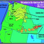
This hot spot phenomenon is what gives us most of the dramatic features and thermal activity in Yellowstone. Somewhat over 2 million years ago, the North American plate moved the Yellowstone region over a plume that was bringing large amounts of magma to not far below the surface. This molten rock shoved its way into the existing rocks, causing them to arch upward to make room. As more magma rose, a magma chamber formed and grew, which greatly increased the arching up of the overlying rocks and caused them to crack. Figure 6 shows the sequence of events that followed over the next several hundred thousand years. Figure 6. Cross section showing the sequence of events that produced the calderas. The ejected rock and steam spread up and out as a billowing incandescent cloud, probably traveling at 50 to 100 miles (80-160 km) per hour and being pushed by the material behind it. As it traveled and expanded, the cloud cooled and deposited ash over the northern Rockies and the Great Plains. In Iowa, for example, the ash was still as much as 3 inches (8 cm) thick. The total volume of erupted ash was about 600 cubic miles (2500 cu km)!
The explosion probably lasted for a period of days or weeks. Volcanic ash, unlike wood or coal ash, is not the residue left from something that has burned, but rather fine-grained rock. An outcrop of this ash deposit can be seen in the park at Golden Gate [GEO.7] south of Mammoth Hot Springs, where it’s called the Huckleberry Ridge tuff. In places, it’s 550 feet (170 m) thick. The unsupported roof of the magma chamber collapsed to create a circular depression that resembled a huge crater, called a caldera (Figure 6C). The plume that was the source of all the magma didn’t stop, however, and continued to send up more magma. Some of this flowed out onto the caldera, partly filling it with rhyolite lava (Figure 6D). Rhyolite is a volcanic rock that has high silica content, which makes it very viscous (stiff and tacky), so that it flows very slowly. Henrys Fork Caldera Event. The plume continued to send up more magma, now using somewhat different plumbing, and the whole caldera process was repeated, with the center of the action being just west of Yellowstone Park in the area of Island Park, Idaho. This culminated in a new major explosion 1.3 million years ago; the debris was again mostly ash. This Mesa Falls tuff can be seen at Mesa Falls [GEO.8] west of the park boundary. The eruption was smaller than the Huckleberry Ridge tuff eruption. Yellowstone Caldera Event. These two major eruptions set the stage for the third and latest explosion 640,000 years ago, the one depicted in Figure 6 and the best studied. The earlier ones were similar but have been partly obscured since. This one formed the present Yellowstone caldera.
Rocks and ash blown out this time are called the Lava Creek tuff. You can see this tuff on the west side of the road just north of Gibbon Falls [GEO.9], at Tuff Cliff near Madison Junction, and at the top of the Lewis River Canyon cliffs on the South Entrance Road [GE0.10] . This latest eruption, with ash beds occasionally exceeding 1000 feet (300 m) in thickness, produced a volume of 240 cubic miles (1000 cu km) of ash, which makes it intermediate in scale between the two previous calderas. In comparison with the impressive eruption at Mount St. Helens, Washington, in May 1980, the Lava Creek eruption blew out about 1000 times more rock. The Mount St. Helens output of volcanic debris was about 0.25 cubic miles (1 cu km). The caldera resulting from the Lava Creek eruption is approximately 30 by 45 miles (48 by 72 km) across, so calling it a crater is an understatement. A good place to see the northern edge of the caldera is along the east-west stretch of road that leads from Madison Junction to Gibbon Falls [GEO.11]. You may have noted that the intervals between the three caldera-forming events were 700,000 and 700,000 years, and the last caldera explosion was 640,000 years ago. We’ll discuss below whether we are due for another soon. Post-Caldera Lavas. After the cataclysmic Yellowstone eruption, the plume kept sending up magma that erupted at intervals for several hundred thousand years. It spilled out onto the caldera floor as rhyolite flows (see Rhyolite and the Plateau of Fire, 49), filling much of the caldera. This explains why there is no deep hole or crater now visible in or near the Yellowstone caldera. It is dicult to get a sense of the Yellowstone caldera when you’re in the park. In fact, the existence of a caldera of this size was not proposed until the 1960s. After many years of mapping, geologists realized the following: First, all the outcrops we now call Lava Creek tuff stem from one event. Second, the tuff is seen only outside an oval area that we now know as the caldera.
(Some Lava Creek tuff is also presumably buried under the later lavas that mostly fill the caldera.) Third, the tuff layers seen in other states (as far away as Iowa) are also from the Yellowstone area. A good place to get a feel for this enormous event is along the Grand Loop Road in the vicinity of Gibbon Falls south of Norris. The 5 miles of highway between Madison Junction and Gibbon Falls parallel the caldera edge. On the north side of the road, you can see a cliff whose upper part is Lava Creek tuff. This tuff was left when the caldera, which was on the south side here, slid down along a fault during its collapse (see Figure 6C). Over the past 640,000 years, the cliff has been eroded back a bit, but it still represents that rim fault. If you now drive past Gibbon Falls and go north toward Norris, you have moved away from the caldera and its rim. The parking area about 0.3 mile (0.5 km) from the falls allows you access to a very tall, nearly vertical wall of Lava Creek tuff, which is cream colored with hints of pink. Basaltic Volcanism. Another type of volcanic rock encountered in the park is basalt. Good examples can be seen near Tower Fall [GEO.12]. (There’s a description of columnar jointing in basalt on 215.) Since basalt contains less silica than rhyolite, basalt flows out as sheets that sometimes spread for miles.

