
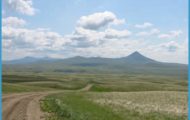
A number of the peaks you see from the Chief Joseph Highway, including Heart Mountain, Steamboat Hill, and Cathedral Cliffs, are part of a geological enigma, the Heart Mountain detachment. By sliding along for large distances, blocks of rock have covered other sedimentary rocks, some of which were younger. Several dozen such blocks, some in excess of 10 miles (16 km) across, are spread over an area 60 miles (97 km) long. It is thought that they slid southeastward along a nearly horizontal fault surface, which today has an average slope of only two degrees. It may be that this region tilted, so that the slope at the time was steeper. Geologists have advanced numerous hypotheses to explain how these enormous blocks could overcome the frictional resistance and slide distances of many miles. The debate is hot and heavy with no clear solution yet in sight. Unfortunately, large parts of the area are buried under volcanic rocks, hiding any evidence that might be helpful in solving the problem.
Going west at the junction of Wyoming 296 and U.S. 212 takes you to Cooke City and Yellowstone’s Northeast Entrance; east is the Beartooth Highway to Red Lodge. Wyoming 296 leads southeast over Dead Indian Pass to Wyoming 120 and Cody, Wyoming, or Belfry, Montana. Watch for Crazy Creek Falls, about 2.5 miles (4 km) west of the highway junction and nearly opposite the campground with the same name. It’s an unusually broad waterfall. There are five forest service campgrounds and several trailheads between the junction and Cooke City. Those south of the Wyoming/Montana state line are in the Shoshone National Forest and those north of it in the Gallatin National Forest. You’ll find good fishing access for the Clarks Fork River. Clarks Fork joins the Yellowstone River near Laurel, Montana. Don’t confuse this river with the Clark Fork of the Columbia in western Montana.
The Case of the Wandering Mountains Photo Gallery


