
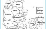
Counties: Sonderjyllands amt, Ribe amt, Vejle amt, Ringkobing amt, Arhus amt, Viborg amt and Nordjyl-lands amt.
The peninsula of Jutland (Jylland), the largest geographical unit in Denmark, extends INI from the mainland of Germany (Schleswig-Holstein), bounded by the North Sea, the Skagerrak and the Kattegat. Its southern border with Germany is Denmark’s only land frontier. Jutland offers a wide variety of attractions, including beautiful bathing beaches, wide expanses of heath and woodland and interesting towns.
Formerly devoted exclusively to farming and fishing, Jutland now has well-developed industries, though agriculture still plays an important part in its economy (export of pork and bacon). Its land, half of which was still covered by heath as recently as the 19th c. has been settled and made fertile. The drift of population from Jutland to Copenhagen has been halted within the last decade, and indeed to some extent reversed: the attractions of life in the country’s smaller towns are now increasingly appreciated.
The line of the Danish-German frontier, long disputed and fought over, was finally established in 1920 after a referendum and reinforced after the German occupation of 1940-5. In recent years the Danish minority S of the frontier and the German minority in Jutland have established reasonably good-neighbourly relations.
The beauty and interest of Jutland can be discovered in the two itineraries suggested here, with a variety of attractive excursions. One route goes along the W side of the peninsula at some distance from the coast; the other traverses eastern Jutland, ending at Frederikshavn, from which there is a ferry service to Gothenburg in Sweden.
Tonder to Holstebro (Road 11). Starting from the frontier village of Seed, the road comes to Tonder (pop. 7500; Missjonshotellet, 90 youth hostel; camp site), referred to as a good harbour by the Arab geographer Idrisi as early as 1130. In the 16th c. a series of dikes was built to protect the town from frequent flooding; as a consequence this former port town is now more than 10 km (6 miles) from the coast. Tonder has an old established lace-making industry, the products of which are still much in demand. The town has preserved many old buildings, including the Digegrevens GSrd in Vestergade and the Old Pharmacy in ©stergade. The Kristkirke (richly decorated interior) has a tower belonging to an earlier church. The Museum contains interesting collections of Dutch tiles and pillow-lace. The town is now the nesting place of many of the storks which used to make their homes in Ribe and other Jutland towns.
To the W of the town is the district of Mogeltonder, probably older than Tonder itself, with a church whose earliest parts date from about 1200. The organ is one of the oldest in the country. Slotsgade, lined with old houses, leads N to Schackenborg Castle. The park was laid out in the 17th the present building is 19th c.
Centre Hotel, 11 youth hostel), with a Cistercian abbey founded in 1144. This now serves as a religious folk high school and for other ecclesiastical purposes. Of the old monastic buildings only part of the E wing remains. The ‘church (1173-1300), in a mingling of Romanesque and Gothic styles, has no tower; it contains an altarpiece (c. 1500) and a painted reliquary (1300). Opposite the main buildings stands a 25 m (80 ft) high tower, with a carillon (plays at 8 and 11 a.m. and 3 and 9 p.m.).
Along the W coast of Jutland are massive dikes designed to protect the land from the devastating storm tides which used to wreak havoc; in 1634, for example, 6000 people and 50,000 head of cattle were drowned in a single night. A side road at Skaerbaek goes down to the coast.
A causeway 5 km (3 miles) long leads on to the island of Romo (area 99-7 sq. km 38 sq. miles), a popular seaside resort, separated from the German island of Sylt by the Listerdyb. The sandy beach on the W coast is one of the finest in Denmark; the E side of the island is covered with heather. In the Kommandorgard at Toftum, at the N end ofthe island, is a local museum. At the S end stands the Seamen’s Church, with a Renaissance pulpit, a Baroque altar andfive votive models of ships; in the churchyard are the graves of 17th and 18th c. whaler captains. From Havneby a ferry service serves Sylt. Several rare species of birds breed on the mud-flats. If driving to Romo take careful note of the tides which advance quickly and can cover the causeway.
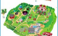
Jutland Jylland Denmark Map Photo Gallery

