
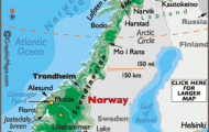
County: Sogn og Fjordane fylke.
Telephone code: 0 57.
Stryn ReisebyrS,
Loen Turistinformasjon,
N-6878 Loen; tel. 7 76 77.
Olden Turistinformasjon,
N-6870 Olden; tel. 7 31 05.
Fjordane Reisebyra,
N 6860 Sandane; tel. 6 60 00.
Maloy Informasjonskiosk,
N-6700 Maloy; tel. 5 13 03.
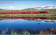
RECREATION and SPORTS. Sailing, fishing, climbing.
Across the Strynsetv and along Road 60 on the steep N shore of the fjord, to Loen (Alexandra Hotel, 373 SB; Pensjonat, 56 Richard’s Motell, 40 SB; Gjeste-hus, 24 b.), at the mouth of the beautiful Loendal (small octagonal wooden church, 1937). From here SkUla (1937 m 6355 ft) can be climbed (6 hours, with guide). From Loen a narrow road runs 14 km (9 miles) along the E side of the picturesque Loenvatn (alt. 43 m (140 ft), area 1 0-2 sq. km (4 sq. miles), greatest depth 1 93 m 635 ft) by way of the Bdai tourist resort to Kjenn-dal, under the N side of the Nonsnibba (1 823 m 5981 ft). Above the W shore of the Loenvatn rises the snow-capped peak of the Ramnefjell or Ravnefjell (2003 m 6570 ft), a northern outlier of the extensive snowfields of the Jostedalsbre ( 146). To the E of Kjenndal rises the Lodalskappa.
Road 60 continues along the shores ofthe fjord from Loen to Olden (Fjordhotell, 80 Yris Pensjonat, 20 b.), at the S end of the fjord, with a church (1746-9, restored 1 971). From here a road runs 4-5 km (3 miles) S through the beautiful Olderdal to Eide, on the northern shore of the ‘Oldenvann (alt. 37 m (120 ft); area 8-4 sq. km (3 sq. miles); 11 km (7 miles) long, up to 90 m 295 ft deep), and continues along the lake (motorboat services), past several waterfalls (views of snow-covered hills to right and left), to Rustoy (13 km 8 miles), at the S end ofthe lake. From here it is another 5-5 km (3i miles) (narrow road places for passing) to Briksdal (alt. 150 m (490 ft); inn), from where an hour’s walk brings one to where the Briksdalsbre, an offshoot of the Jostedalsbre snowfields, rears its bluish ice masses above the scrub forest.
From Olden, Road 60 runs along the S side of the fjord and comes in 17 km (1 0 miles) toInnvik, with a viewtothe S ofthe snow-covered Storlaugpik (1556 m 5105 ft) and the Ceciliekruna (1775 m 5824 ft).
Beyond Utvik, an attractive, widely scattered settlement (church), the road leaves the shore of the fjord and winds its way (magnificent views ofthe fjord), up to the Utvikfjell (640 m 2100 ft). From Utvikfjell there is a splendid panorama, with the Jostedalsbre to the S. Road 14 then descends to Byrkjelo. To the left is the Sognefjord ( 239): to the right is Sandane, attractively situated at the E end ofthe Gloppenfjord, anotherarm of the Nordfjord (pop. 2000; Sivertsens Hotel, 80 Firdaheimen, 37 b.). The Nordfjord Folk Museum is in Sandane (1 6 old buildings). On the W side of the fjord are the Gjemmestad church and several Iron Age burial mounds; on the E side is one of the largest burial mounds in Vestland, the Tinghogjen (50 m (165 ft) across, 7 m 23 ft high), which captures the last evening sunlight on Midsummer Day.
The E shore of the Gloppenfjord leads to its junction with the Utfjord, another part of the Nordfjord. To the right lies the little airfield of Sandane. From Anda, on the point between the two fjords, there is a car ferry (1 0 minutes) to Lote, on the N side of the Utfjord.
From Lote, Road 14 runs NW to Nordfjordeid (pop. 1700; Nordfjord Hotell, 110 Heimen, 80 b.) across the strip of land between the Hundviksfjord and the Eidsfjord, and from there continues W along the N side ofthe Eidsfjord. Beyond Starheim, birthplace of the popular poet Mathias Orheim (1884-1958: hut with souvenirs ofthe poet), it reaches the main arm of the fjord system, the Nordfjord proper. After passing through Bryggja, it comes to Almenningen, from which there is a view of Europe’s highest cliff, Hornelen, rising vertically from the lake to a height of 860 m (2820 ft); in popular legend this was the place where witches and trolls held their revels. Soon afterward, a bridge 1224 m (1300 yds) long crosses the Ulvesund to Mciloy (Hagens Hotel, 80 b.), on the island of Vagsoy. Of interest here are the Kan-nesten, a rock eroded into hourglass shape (11 km (7 miles) from MSloy on the shore of the fjord), and an old trading station on the Vagsberg, with seven historic buildings. A boat can be taken from Hagens Hotel to Vingen (opposite Hornelen), with the largest group of stone carvings in the north, the Hellerist-ningsfelt (2000 figures, mostly stags).
Nordfjord Norway Map Photo Gallery
