
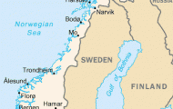
Province: Lapin laani (Lapplands IanLapland). Altitude: 95 m (310 ft). Population: 30,000.
Postal code: SF-96200. Telephone code: 9 91.
jN Kaupungin Matkailutoimisto v (Municipal Tourist Information Office), Aallonkatu 2; tel. 1 62 70
HOTELS. Pohjanhovi, Pohjanpuistikko 2, 450 SP; City-Hotelli, Pekankatu 9, 152 Polar Rovaniemi, Valtakatu 23,1 01 SP; Lapinportti, Kairatie 2, 40 b„ SP. OUTSIDE THE town: Rova Motelli,
Kemintie, 143 Polar Ounasvaara, 75 SP.; Pohtimolampi, 150 b.
HOLIDAY and SUMMER HOTELS. Domus Arctica, Ratakatu 6-12, 360 b. (June to August); Kesahotelli, Kairantie 75, 108 b. (9 June to 31 July); Oppipoika, Korkalonkatu 33, 40 SP (8 June to 9 August).
EVENTS. Ounasvaara Winter Games (24-25 March); Midnight Sun Festival on Mt Ounasvaara (23 June); Arctic Yacht Race for light boats on Iso Vietonen Lake, 50 km (30 miles) NW of the town (June); Ars Arctica art exhibition (end June to end July).
SPORTS and RECREATION. Tennis, golf, riding, shooting, fishing, swimming, rowing, sailing; skiing in winter (downhill and cross-country), reindeer sledge-rides.
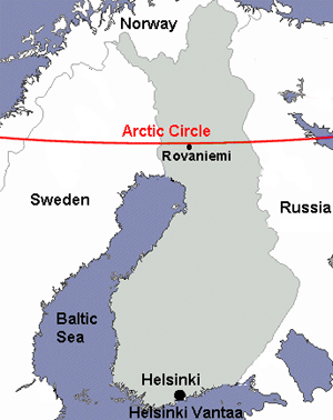
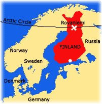
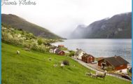
Rovaniemi is the administrative capital of the Finnish province of Lapland, by far the largest of the country’s provinces, with an area of over 90,000sq. km (35,000sq. miles). The only town in Lapland and the province’s economic and cultural hub, it stands at the junction of the Kemijoki, Finland’s longest river (510 km 320 miles) with the Ounasjoki (320 km 200 miles).
There was a settlement here in the 1 6th c. when the tax-collectors of the region’s Swedish and Russian rulers first began to appear in these northern territories. With the increase in the demand for timber following the development of industry, Rovaniemi increased considerably in importance, lying as it did at the junction of two of the principal rivers down which rafts could be floated from the interior of Lapland and into the Baltic. The present town was carved out of the rural commune in 1 929 and, in 1 938, it became the capital ofthe province of Finnish Lapland. It received its municipal charter in 1960, and plans to increase its development potential by the incorporation of the rural commune are being considered.
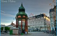
Until quite recently, Rovaniemi, like other places in the northern territories, consisted almost entirely of timber houses. In the winter of 1 944-5, however, more than four-fifths of the town was burned down during the fighting between Finnish and German forces. Alvar Aalto was commissioned to rebuild the town and based the layout ofthe main streets on the pattern of a reindeer’s antlers. The buildings erected since the war are almost all of stone, and
Arctic Circle, Rovaniemi some of the public buildings have provided a model for the whole of Lapland by their functional conception and their adaptation to the landscape.
Rovaniemi attracts about 400,000 visitors each year, and accordingly the service trades are of major importance to the economy of the town.
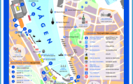
SIGHTS, In the SE ofthe town, nearthe large two-level road and railway bridge, are the Provincial Government Offices. To the S, beyond the railway line, stands the Lutheran Church (Bertil Liljequist, 1 950), with an altarpiece, The Source of Life, by Lennart Segerstrah. To the left of the entrance a stone marks the site of the earlier church (1817-1944). Behind the church is the churchyard, with a large war memorial to the dead of 1 939-45. Opposite the church is a monument to the Finnish freedom fighters of 1 91 8. At No.
11 Hallituskatu is the Lappia Hall (Alvar Aalto, 1975), with a threatre and conference hall and the Lapland Provincial Museum (material illustrating the traditions of the Lapps and gipsies; ornithology). Adjoining, at No. 9 Hallituskatu, the Municipal Library (Alvar Aalto, 1 965) houses a collection of minerals and an exhibition room. On the E bank of the Ounakoski is the Orthodox Church (Toivo Paatela and llmari Ahonen, 1957), with valuable icons from Valamo monastery.
To the NW of the town, on the banks of the Kemijoki, is the Pohjanhovi Hotel. To the N, in the gardens by the river, stands a bronze statue of a bark-stripper (Kallervo Kallio, 1 939-52). 4 km (2Jr miles) S of the middle of the town, also on the Kemijoki, are the Poykkola Ethnographic Museum (old houses; 19th c. peasant culture) and the Lapland Forestry Museum, which illustrates the work of the timber-workers immortalised in the sculpture of Kallervo Kallio.
SURROUNDINGS. SE of Rovaniemi, on the left bank of the Kemijoki, is the hill of Ounasvaara (204 m (670 ft), with a cafe (view), a ski hut and a large ski-jump. From the top of the hill, the midnight sun is visible from 18 to 28 June. 8 km (5 miles) N the road to Kemijarvi crosses the Arctic Circle (Finnish Napapiiri. 49). Here there is a log cabin with a cafe and a post office (special postmark), and visitors can get a certificate to show that they have crossed the Arctic Circle. Nearby is the Lappiand children’s village, opened in October 1979. 30 km (19 miles) from Rovaniemi, on the Aavasaksa road, is the Pohtimolampi tourist and sports resort (hotel, 150 restaurant), with a ski-lift and reindeer-driving for visitors.
Rovaniemi Finland Map Photo Gallery