
Counties: Sor-Trondelag fylke, More og Romsdal fylke.
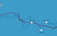
The Sunndal is crossed by the lower course of the River Driva, which is joined at Oppdal by the Alma. The valley extends W from Oppdal, roughly half-way between DombSs and Trondheim, and reaches the Sunndalsfjord at Sunndals0ra.
Oppdal (alt. 545 m (1 790 ft); pop. 3500; Hellaugstol Fjell Motell, 40 Nor Turisthotell, 70 Fagerhaug Inn Motell, 76 Oppdal Turisthotell, 90 Oppdal Motell, 65 youth hostel) lies in a wide part of the valley, at an important road junction where Road 16 branches off from E6 (DombSs-Trondheim) and runs W. The Alma, coming from the E, flows into the Driva here. Oppdal is a tourist and winter sports resort, with a chair-lift, several ski-tows and more than 70 km (45 miles) of cross-country ski trails. The town’s main sources of revenue are stone quarries and the manufacture of furniture, sporting goods and glass. There is an interesting district museum (old houses, store-rooms (‘stabbur’), etc.). Road 1 6 runs down the valley ofthe Driva, passing a Viking cemetery and, 2-5 (lmiles) from the town, Oppdal church, at the foot of Orsnipen (1378 m 4520 ft). The wooden church dates from the 1 7th c. and has a prominent steeple; the interior furnishings (pulpit, altar) are 17th-18th c.
At Vognilla road branches off (22 km (14 miles) NW) to the Gjevilvass hut (700 m 2300 ft), set commandingly on the N shore ofthe Gjevilvatn (663 m 2175 ft). From there, an 8-9 hours’walk NW leads to the Trollheim hut (531 m 1740 ft), base for the ascent to the commanding peaks of the Trollheimen range, including the Trollhetta (1614 m (5295 ft); round trip 7-8 hours, with guilde) and Snota, the highest peak in the area (1 668 m (5473 ft); round trip 8-9 hours, with guide).
The old manor-house of Gravaune has an interesting collection of historical weapons and everyday objects. The road continues past the Albu power station to Lenset (521 m 171 Oft) (church). Here a road turns off on the right up the Storlidal, past the Storfall, to the Storlihut (652 m
21 40 ft), another good base for climbs in the Trollheimen area.
After crossing the county boundary the road descends more steeply, with many curves and attractive views, to Gjera (camp site). A rewarding detour (to the left) through the Jenstadjuvet gorge (waterfall) into the Gruvedal (fine walking country) can be made from here.
The road continues down the Sunndal alongside the river, now known as the Sunndalselv.
Romfo (1 38 m 453 ft) has a church (1 824); a short distance W is the Driva power station (140 MW).
Fale is a good fishing area (salmon). Beyond this is Groa (100 m (330 ft); camp site); ahead, to the right, is Hov-snebba (1 609 m 5280 ft).
The river is crossed on the Elverhey bridge. On the far side are the Sunndal Bygdemuseum and an Iron Age cemetery.
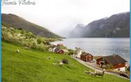
Sunndalsora (pop. 5000; Mullerhotell, 115 youth hostel; camp site) lies at the head of the Sunndalsfjord, which is enclosed by snow-covered mountains. It has a large power station (290 MW) and an aluminium plant. Visitors can tour the fishery research station. There is a charming road along the SW shore of the Kristiansund fjord to Eidsvag (40 km 25 miles) and Molde (95 km (60 miles): 193). 39 km (25 miles) S of Sunndalsora (2 km (1J miles) on the Molde road, then turn left) is the Aursje (hut, 860 m 2920 ft), with one of the largest dams in Norway. Water is channelled under pressure from here to the Sunndalsora power station.
The road to Kristiansund continues along the steep E shore of the fjord for another 8-5 km (5 miles; several tunnels), then runs through the wooded (Dpdalseid area.
In another 11 5 km (7 miles), on the left, is the octagonal church of Alvundeid. At the Alvundfoss (85 m (280 ft) high; power station) the road divides. Road 1 6, to the left, now runs along the SW shore of the Alvundfjord.
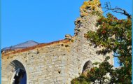
Tingvoll (pop. 1000; Sortdal GjestgSrd, 20 camp site), on the Tingvollfjord, has an interesting 13th c. stone church containing a runic stone and remains of frescoes. The road continues along the NE shore ofthe fjord.
From Kvisvikthere is a ferry to Kvalvag, on the island of Frei. Road 1 6 continues from KvalvSg to Kristiansund.
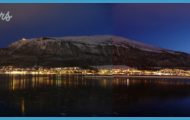
Kristiansund (pop. 19,000; Fosna Hotell, 76 Grand, 214 Skoglyst Motell, 22 youth hostel; camp site; ), the county town of More og Romsdal, was founded in 1742. Built on three islands which enclose the harbour, it is the base of a large fishing fleet and does a large trade in the shipment of fish products. It was destroyed during the Second World War and was rebuilt in modern style. It has a fine church by Odd 0stbye (1964). From the Varden lookout tower, to the NW of the town, there is a good view of the islands of Nordland, Gomaland, Kirkeland, with the main part of the town, and Innland, connected to each other by bridges.
In the open sea 15 km (10 miles) NW of Kristiansund (boat service) is the island of Grip (youth hostel),the largest of a group of 82 islands and islets, with a lighthouse and a 15th c. wooden church.
Sunndal Norway Map Photo Gallery
