
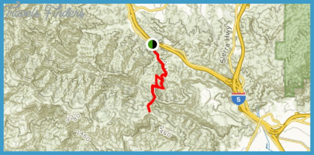
24255 The Old Road Newhall
Hiking Distance: 5.6 Miles Round Trip Hiking Time: 3 Hours Configuration: Two Out-And-Back Trails Elevation Gain: 1,100 Feet Difficulty: Moderate To Strenuous Exposure: Mostly Exposed Dogs: Allowed
Maps: U.S.G.S. Oat Mountain
East Canyon And Rice Canyon Sit On The North-Facing Slope Of The Santa Susana Mountains Just South Of Santa Clarita. The Canyons Are Included In The 4,000-Acre Santa Clarita Woodlands Park, Managed By The Santa Monica Mountains Conservancy.
Santa Clarita Woodlands Park Map Photo Gallery

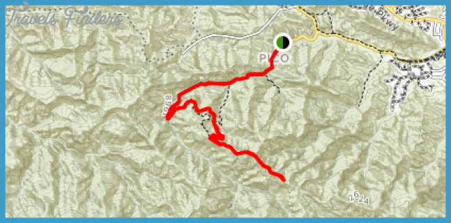

This Hike Includes Two Out-And-Back Trails That Lead Up Both Canyons To Overlooks. The East Canyon Trail Is A Dirt Fire Road That Climbs Through Forested Pockets Of Coast Live Oak, Bay Laurel, Black Walnut, Big Leaf Maple, Toyon, And Douglas Fir. The Hiking, Biking, And Equestrian Trail Leads Nearly Four Miles To The Weldon Canyon Motorway, Straddling The Ridgeline. The Trail Emerges At An Overlook (Shy Of The Ridge), With Magnificent Views Across Santa Clarita Valley.
Rice Canyon, An Adjoining Drainage To The Northwest, Diverts From East Canyon And Follows Seasonal Rice Creek Up The Canyon Bottom To A Grassy Knoll With An Overlook Of The Canyon And Surrounding Mountains. The Rice Canyon Trail (For Hikers Only) Winds Through The Forested Canyon At An Easy Grade, Gaining Only 300 Feet To The Plateau Dotted With Oaks Above The Canyon Floor. En Route, The Trail Leads Through Open Pastoral Meadows And Groves Of Oaks, Sycamores, Cottonwoods, And Willows.
To The Trailhead
From The Golden State Freeway (Interstate 5) In Santa Clarita, Exit On Calgrove Boulevard. Head South On Calgrove Boulevard, Which Quickly Becomes The Old Road. Follow The Frontage Road One Mile South To The Signed Trailhead On The Right (Located Just Before The Old Road Goes Under I- 5.) Park Along The Right Side Of The Road For Free, Or Pull Into The Trailhead Parking Lot On The Right For A Fee.
The Hike
Walk East On The Side Road, Parallel To The Old Road, To The Signed Trailhead Just Before Of The Pay-Parking Lot. Bear Right, Head Past The Botanical Garden And Vehicle Gate, And Enter The Mouth Of East Canyon. Follow The West Side Of Ephemeral East Canyon Creek. At 0.3 Miles Is A Signed Trail Fork. The Right Fork Heads Up Rice Canyon. For Now, Continue Straight, Staying In East Canyon While Gently Climbing Past Oak Groves. The Canyon Narrows At 0.7 Miles And The Vegetation Thickens. Climb Out Of The Canyon Bottom, And Wind Up The West Canyon Slope With Far-Reaching Vistas. At 1.8 Miles Is A Short, Steep Climb. As The Path Curves Left, Take The Unsigned Footpath To The Right. Walk 100 Yards To A Lone Majestic Oak On A Knoll Overlooking The Fir And Pine Forest Deep In Rice Canyon. Enjoy The Great Views That Span Across The Santa Clarita Valley.
To Extend The Hike Along This Route, The East Canyon Trail Continues Less Than A Mile To The Weldon Canyon Motorway Atop The Ridge. The Left Fork Traverses The Ridge And Descends The Mountain Into Weldon Canyon. The Right Fork Stays On The 3.8-Mile East Canyon Trail To Its Terminus At A Trail Split. To The Right, Bridge Road Follows The Ridge To Oat Mountain. To The Left, Corral Sunshine Motorway Leads To Mission Point And O’Melveny Park.
Return Down The Mountain To The Junction At The Foot Of Rice Canyon. Veer Left Into Rice Canyon And Stroll Through The Open Meadow As The Canyon Narrows. Enter The Shade Of The Oaks And Cross The Seasonal Drainage. Pass Through A Small Oak-Rimmed Meadow, Then Duck Back Into The Forest. Cross The Stream Four More Times, Weaving Up The Canyon. Ascend The West Canyon Wall To An Unsigned Y-Fork One Mile From The Junction. The Right Fork Leads 25 Yards To A Knoll With A Stately Oak And A Vista Of The Forested Canyon. The Left Fork Heads Steeply Up The Mountain. Return Back Along The Same Trail.


